IMAGES TAKEN NEAR TO
Sulgrave Road, LONDON, W6 7QU
Introduction
This page details the photographs taken nearby to Sulgrave Road, W6 7QU by members of the Geograph project.
The Geograph project started in 2005 with the aim of publishing, organising and preserving representative images for every square kilometre of Great Britain, Ireland and the Isle of Man.

There are currently over 7.5m images from over14,400 individuals and you can help contribute to the project by visiting https://www.geograph.org.uk
Image Map
Images are licensed for reuse under creativecommons.org/licenses/by-sa/2.0
Notes
- Clicking on the map will re-center to the selected point.
- The higher the marker number, the further away the image location is from the centre of the postcode.
Image Listing (125 Images Found)
Images are licensed for reuse under creativecommons.org/licenses/by-sa/2.0
Image
Details
Distance
1
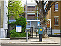
Richford Gate Primary Care Centre
No visitor car parking. Pay here.
Image: © Robin Webster
Taken: 13 May 2012
0.06 miles
2

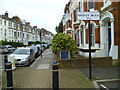
Essex Court, Hammersmith Grove W6
At the junction with Beauclerc Road W6
Image: © Robin Sones
Taken: 19 May 2009
0.06 miles
3

Orange Way after Wiltshire (629)
Trussley Road takes the Way under the railway to Sulgrave Road.
Image: © Shazz
Taken: 23 Sep 2013
0.06 miles
4
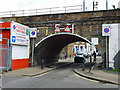
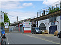
Railway bridge over Trussley Road
The Hammersmith and City Line crosses the short, sinuous and obscurely located Trussley Road.
Image: © Robin Webster
Taken: 13 May 2012
0.06 miles
5
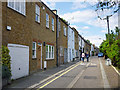
Grove Mews
One of the more tucked away places in Hammersmith.
Image: © Robin Webster
Taken: 13 May 2012
0.07 miles
6
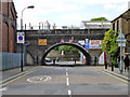
Railway bridge HC25A, Trussley Road, W6
The Hammersmith and City Line crosses. HC25A may apply to more of the viaduct to the right, HC25B certainly applies to a length of viaduct to the left.
Image: © Robin Webster
Taken: 13 May 2012
0.07 miles
7
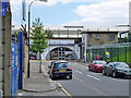
Trussley Road, W6
Collins Motors occupies railway arches, as do the other businesses in this short and bendy but through road.
Image: © Robin Webster
Taken: 13 May 2012
0.07 miles
8
Orange Way after Wiltshire (630)
This is Batoum Gardens going east.
Image: © Shazz
Taken: 23 Sep 2013
0.08 miles
9
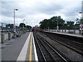
View from Goldhawk Road station towards Hammersmith
The line here was opened in 1864. However, Goldhawk Road station was not opened at this location until 1 April 1914 when the station now known as Shepherd's Bush Market, but then as Shepherd's Bush, was moved from its original location between Uxbridge Road and Goldhawk Road to its present position on the north side of Uxbridge Road. Trains on the Hammersmith & City Line serve the station and now also, in an effort to improve its reliability, the Circle Line. The office blocks at Hammersmith can just be seen in the distance.
Image: © Marathon
Taken: 15 Jun 2011
0.08 miles
10
Trussley Road, W6
Warren Evans beds occupy arches under the railway.
Image: © Robin Webster
Taken: 13 May 2012
0.10 miles