IMAGES TAKEN NEAR TO
Loris Road, LONDON, W6 7QA
Introduction
This page details the photographs taken nearby to Loris Road, W6 7QA by members of the Geograph project.
The Geograph project started in 2005 with the aim of publishing, organising and preserving representative images for every square kilometre of Great Britain, Ireland and the Isle of Man.

There are currently over 7.5m images from over14,400 individuals and you can help contribute to the project by visiting https://www.geograph.org.uk
Image Map
Images are licensed for reuse under creativecommons.org/licenses/by-sa/2.0
Notes
- Clicking on the map will re-center to the selected point.
- The higher the marker number, the further away the image location is from the centre of the postcode.
Image Listing (85 Images Found)
Images are licensed for reuse under creativecommons.org/licenses/by-sa/2.0
Image
Details
Distance
1

Batoum Gardens mural
Painted by Russell Barrett, it's probably better viewed in the autumn or winter when it's not obscured by the trees.
Image: © Phillip Perry
Taken: 26 Jun 2008
0.03 miles
2
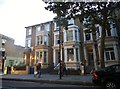
Houses on Shepherd's Bush Road, Hammersmith
No doubt very few Victorian town houses are used as houses any more. Most are now flats and the remainder offices.
Image: © David Howard
Taken: 11 Sep 2016
0.04 miles
3
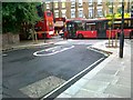
Orange Way after Wiltshire (630)
This is Batoum Gardens going east.
Image: © Shazz
Taken: 23 Sep 2013
0.05 miles
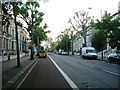
4

London : Hammersmith : Shepherd's Bush Road
Looking towards a pedestrian crossing on this road which heads towards the common.
Image: © Lewis Clarke
Taken: 14 Aug 2010
0.06 miles
6
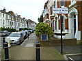
Shops on Shepherds Bush Road
Looking towards Blythe Road
Image: © David Howard
Taken: 6 Jan 2014
0.07 miles
7
Shepherd's Bush Road, W6
Compare this photo with this one Image
Image: © Phillip Perry
Taken: 26 Jun 2008
0.08 miles

9

Another 220
In Shepherd's Bush Road close to Sterndale Road and Barb Mews.
Image: © Phillip Perry
Taken: 19 Aug 2006
0.09 miles
10

Orange Way after Wiltshire (629)
Trussley Road takes the Way under the railway to Sulgrave Road.
Image: © Shazz
Taken: 23 Sep 2013
0.09 miles