IMAGES TAKEN NEAR TO
Millers Way, LONDON, W6 7NH
Introduction
This page details the photographs taken nearby to Millers Way, W6 7NH by members of the Geograph project.
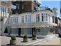
The Geograph project started in 2005 with the aim of publishing, organising and preserving representative images for every square kilometre of Great Britain, Ireland and the Isle of Man.

There are currently over 7.5m images from over14,400 individuals and you can help contribute to the project by visiting https://www.geograph.org.uk
Image Map
Images are licensed for reuse under creativecommons.org/licenses/by-sa/2.0
Notes
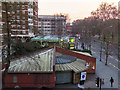
- Clicking on the map will re-center to the selected point.
- The higher the marker number, the further away the image location is from the centre of the postcode.
Image Listing (329 Images Found)
Images are licensed for reuse under creativecommons.org/licenses/by-sa/2.0
Image
Details
Distance
1
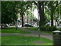
Shepherd's Bush Green, W12
Shepherd's Bush Green on the corner of Goldhawk Road, looking down Shepherd's Bush Road.
Image: © Phillip Perry
Taken: 15 Jun 2008
0.03 miles
2
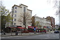
Shops and houses on Shepherd's Bush Green, London
Image: © JThomas
Taken: 13 Apr 2019
0.03 miles
3
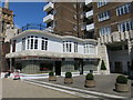
The Grampians
Grade II listed https://www.historicengland.org.uk/listing/the-list/list-entry/1390753
Image: © Oast House Archive
Taken: 5 Jul 2016
0.04 miles
4
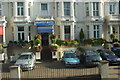
49-51 Shepherd's Bush Green, W12
A small row of the only 5 'period' houses that are left on Shepherd's Bush Green, featuring the Grantly Hotel at No.50. The row consists of B&B's and a college all positioned in a private road.
Image: © Phillip Perry
Taken: 2 Sep 2010
0.04 miles
5
The Grampians
Grade II listed https://www.historicengland.org.uk/listing/the-list/list-entry/1390753
Image: © Oast House Archive
Taken: 5 Jul 2016
0.04 miles
7
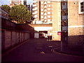
Shepherd's Bush station (ex-LSWR)
Nothing left of this former station that closed in 1916, the line ran from north of Kensington Olympia station serving this station, Grove Road, and onto joining the District Line between Hammersmith and Ravenscourt Park stns. The road surface was the track bed and the entrance was on the back wall where the garage is leading up to Shepherd's Bush Road.
See also: Image, Image
Image: © Phillip Perry
Taken: 6 Oct 2010
0.05 miles
9
Shepherds Bush
BP Filling Station at Shepherds Bush.
Image: © Peter McDermott
Taken: 17 Feb 2016
0.05 miles
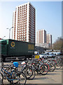
10
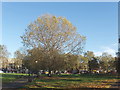
Trees on Shepherds Bush Common
The common is an 8 acre triangular open space, acquired by act of parliament in 1871. It is surrounded by busy roads. The photo is looking North towards a row of small shops. There is a shopping mall and multi-screen cinema on the south side.
Image: © David Hawgood
Taken: 9 Nov 2005
0.05 miles