IMAGES TAKEN NEAR TO
Hammersmith Broadway, LONDON, W6 7AB
Introduction
This page details the photographs taken nearby to Hammersmith Broadway, W6 7AB by members of the Geograph project.
The Geograph project started in 2005 with the aim of publishing, organising and preserving representative images for every square kilometre of Great Britain, Ireland and the Isle of Man.

There are currently over 7.5m images from over14,400 individuals and you can help contribute to the project by visiting https://www.geograph.org.uk
Image Map
Images are licensed for reuse under creativecommons.org/licenses/by-sa/2.0
Notes
- Clicking on the map will re-center to the selected point.
- The higher the marker number, the further away the image location is from the centre of the postcode.
Image Listing (314 Images Found)
Images are licensed for reuse under creativecommons.org/licenses/by-sa/2.0
Image
Details
Distance
1
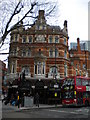
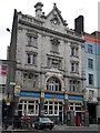
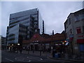
The Swan, Hammersmith Broadway W6
At the junction of Beadon Road W6
Image: © Robin Sones
Taken: 31 Mar 2010
0.01 miles
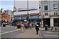
2
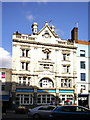
Formerly St Christopher's Inn now called Belushi's
Image: © Alexander P Kapp
Taken: 8 Mar 2009
0.01 miles
3
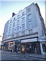
Shops at the end of Shepherd's Bush Road
Image: © David Howard
Taken: 11 Sep 2016
0.01 miles
4
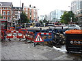
London : Hammersmith - Hammersmith Road Roadworks
Some people have been digging up the road. Centercomms seem to have provided the barriers.
Image: © Lewis Clarke
Taken: 14 Aug 2010
0.01 miles
6
London : Hammersmith - Pedestrian Crossing
A pedestrian crossing on Shepherd's Bush Road A219.
Image: © Lewis Clarke
Taken: 13 May 2011
0.01 miles
7
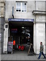
Side entrance to Hammersmith Underground Station, Hammersmith Broadway W6
Image: © Robin Sones
Taken: 31 Mar 2010
0.01 miles
8
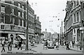
Brook Green Road (now Shepherds Bush Road) at Hammersmith Broadway, 1959
View northward, towards Shepherds Bush. Up to the left is the Police Station and the celebrated Palais de Danse. The southbound trolleybus approaching is on either Route 628 (Craven Park - Clapham Junction or 630 (Harrow Road (Scrubs Lane) - West Croydon). (See also Image]).
Image: © Ben Brooksbank
Taken: 26 Sep 1959
0.01 miles
10
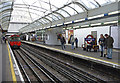
Piccadilly Line platform, Hammersmith, London
Looking along the westbound platform of the Piccadilly Line at Hammersmith.
Image: © Christine Matthews
Taken: 18 Feb 2009
0.02 miles