IMAGES TAKEN NEAR TO
Goldhawk Road, LONDON, W6 0XE
Introduction
This page details the photographs taken nearby to Goldhawk Road, W6 0XE by members of the Geograph project.
The Geograph project started in 2005 with the aim of publishing, organising and preserving representative images for every square kilometre of Great Britain, Ireland and the Isle of Man.

There are currently over 7.5m images from over14,400 individuals and you can help contribute to the project by visiting https://www.geograph.org.uk
Image Map
Images are licensed for reuse under creativecommons.org/licenses/by-sa/2.0
Notes
- Clicking on the map will re-center to the selected point.
- The higher the marker number, the further away the image location is from the centre of the postcode.
Image Listing (130 Images Found)
Images are licensed for reuse under creativecommons.org/licenses/by-sa/2.0
Image
Details
Distance
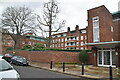
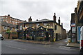
3
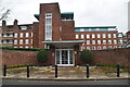
Royal Masonic Hospital Nurses' Home
Grade II listed.
Image: © N Chadwick
Taken: 18 Feb 2023
0.03 miles
4
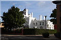
Stamford Brook: Oakbrook Lodge
This building, finished in brilliant white and with an attractive Flemish step-gable, was formerly the Queen Charlotte Maternity Hospital. It is now high-end apartments.
Image: © Dr Neil Clifton
Taken: 2 Oct 2012
0.03 miles
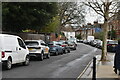
5
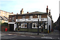
Stamford Brook: The 'Raven'
Almost opposite the exit from Stamford Brook station.
Image: © Dr Neil Clifton
Taken: 2 Oct 2012
0.04 miles
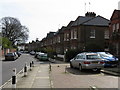
9

27, Ravenscourt Gardens
Grade II listed.
Image: © N Chadwick
Taken: 18 Feb 2023
0.07 miles
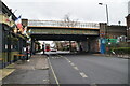
10
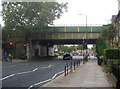
Ravenscourt Park: Railway bridge at Stamford Brook tube station
The railway had been built across the road here by 1869, but Stamford Brook station did not open until 1912. The bridge on view here arrived even later, in 1932, when the railway was widened to accommodate the Piccadilly Line extension west of Hammersmith.
The road is the A402 Goldhawk Road.
The road and everything to the right of it and east of it is inside the boundary of the London Borough of Hammersmith and Fulham, that to the left of the road inside the boundary of the London Borough of Ealing.
Image: © Nigel Cox
Taken: 12 Sep 2018
0.07 miles