IMAGES TAKEN NEAR TO
King Street, LONDON, W6 0SP
Introduction
This page details the photographs taken nearby to King Street, W6 0SP by members of the Geograph project.
The Geograph project started in 2005 with the aim of publishing, organising and preserving representative images for every square kilometre of Great Britain, Ireland and the Isle of Man.

There are currently over 7.5m images from over14,400 individuals and you can help contribute to the project by visiting https://www.geograph.org.uk
Image Map
Images are licensed for reuse under creativecommons.org/licenses/by-sa/2.0
Notes
- Clicking on the map will re-center to the selected point.
- The higher the marker number, the further away the image location is from the centre of the postcode.
Image Listing (211 Images Found)
Images are licensed for reuse under creativecommons.org/licenses/by-sa/2.0
Image
Details
Distance

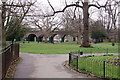
5
Ravenscourt Park
Ravenscourt Park seen from the Premier Inn hotel.
Image: © Peter McDermott
Taken: 6 Nov 2014
0.03 miles
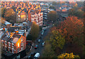
6
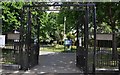
London : Hammersmith - Ravenscourt Park
The origins of Ravenscourt Park lie in the medieval manor and estate of Palingswick (or Paddenswick) Manor, located on the site and first recorded in the 12th century. The historic name still exists today in the name of Paddenswick Road, which runs along the northeast boundary of the park.
Image: © Lewis Clarke
Taken: 13 May 2011
0.04 miles