IMAGES TAKEN NEAR TO
Dalling Road, LONDON, W6 0JB
Introduction
This page details the photographs taken nearby to Dalling Road, W6 0JB by members of the Geograph project.
The Geograph project started in 2005 with the aim of publishing, organising and preserving representative images for every square kilometre of Great Britain, Ireland and the Isle of Man.

There are currently over 7.5m images from over14,400 individuals and you can help contribute to the project by visiting https://www.geograph.org.uk
Image Map
Images are licensed for reuse under creativecommons.org/licenses/by-sa/2.0
Notes
- Clicking on the map will re-center to the selected point.
- The higher the marker number, the further away the image location is from the centre of the postcode.
Image Listing (270 Images Found)
Images are licensed for reuse under creativecommons.org/licenses/by-sa/2.0
Image
Details
Distance
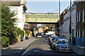
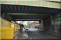
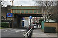
5
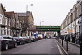
Hammersmith
Studland Street. The bridge carries the District and Piccadilly underground lines.
Image: © Peter Trimming
Taken: 24 Mar 2018
0.02 miles
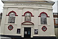
10
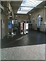
Ravenscourt Park Underground Station ticket office
Image: © Stacey Harris
Taken: 12 Dec 2009
0.04 miles