IMAGES TAKEN NEAR TO
Glenthorne Road, LONDON, W6 0DY
Introduction
This page details the photographs taken nearby to Glenthorne Road, W6 0DY by members of the Geograph project.
The Geograph project started in 2005 with the aim of publishing, organising and preserving representative images for every square kilometre of Great Britain, Ireland and the Isle of Man.

There are currently over 7.5m images from over14,400 individuals and you can help contribute to the project by visiting https://www.geograph.org.uk
Image Map
Images are licensed for reuse under creativecommons.org/licenses/by-sa/2.0
Notes
- Clicking on the map will re-center to the selected point.
- The higher the marker number, the further away the image location is from the centre of the postcode.
Image Listing (298 Images Found)
Images are licensed for reuse under creativecommons.org/licenses/by-sa/2.0
Image
Details
Distance
1

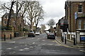
Southerton Road Cycle Dock
This end of Southerton Road has been blocked to vehicles and some of the space used for a hire cycle dock.
Image: © Des Blenkinsopp
Taken: 19 Apr 2018
0.00 miles
3

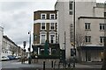
Orange Way after Wiltshire (626)
This is Glenthorne Road and the left turn into Southerton Road is the way to take.
Image: © Shazz
Taken: 23 Sep 2013
0.02 miles

6

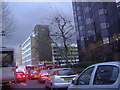
Multi-storey car park on Glenthorne Road, Hammersmith
Image: © David Howard
Taken: 21 Jul 2014
0.03 miles
9
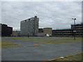
Kings Mall car park, W6
The rather empty 10th (and top) floor of Kings Mall car park in Hammersmith.
Image: © Phillip Perry
Taken: 7 Oct 2010
0.04 miles
10
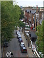
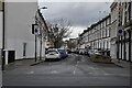
Iffley Road, W6
Taken from across the road on the 10th floor of King's Mall car park.
Image: © Phillip Perry
Taken: 7 Oct 2010
0.05 miles