IMAGES TAKEN NEAR TO
Paradise Gardens, LONDON, W6 0DB
Introduction
This page details the photographs taken nearby to Paradise Gardens, W6 0DB by members of the Geograph project.
The Geograph project started in 2005 with the aim of publishing, organising and preserving representative images for every square kilometre of Great Britain, Ireland and the Isle of Man.

There are currently over 7.5m images from over14,400 individuals and you can help contribute to the project by visiting https://www.geograph.org.uk
Image Map (Loading...)


Getting Data...Please wait
Leaflet Map data © OpenStreetMap
Images are licensed for reuse under creativecommons.org/licenses/by-sa/2.0
Notes
- Clicking on the map will re-center to the selected point.
- The higher the marker number, the further away the image location is from the centre of the postcode.
Image Listing (232 Images Found)
Images are licensed for reuse under creativecommons.org/licenses/by-sa/2.0
Image
Details
Distance
1
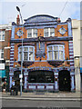
The Salutation
A Fuller's pub on King Street.
Image: © Oast House Archive
Taken: 22 Sep 2016
0.03 miles
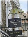
2
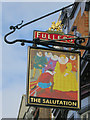
The Salutation sign
Sign for Image], a Fuller's pub on King Street.
Image: © Oast House Archive
Taken: 22 Sep 2016
0.03 miles
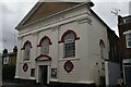
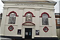
9
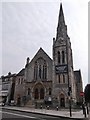
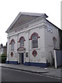
Rivercourt Methodist Church, King Street W6
Image: © Robin Sones
Taken: 18 Aug 2016
0.04 miles