IMAGES TAKEN NEAR TO
Park Place, LONDON, W5 5NQ
Introduction
This page details the photographs taken nearby to Park Place, W5 5NQ by members of the Geograph project.
The Geograph project started in 2005 with the aim of publishing, organising and preserving representative images for every square kilometre of Great Britain, Ireland and the Isle of Man.

There are currently over 7.5m images from over14,400 individuals and you can help contribute to the project by visiting https://www.geograph.org.uk
Image Map
Images are licensed for reuse under creativecommons.org/licenses/by-sa/2.0
Notes
- Clicking on the map will re-center to the selected point.
- The higher the marker number, the further away the image location is from the centre of the postcode.
Image Listing (111 Images Found)
Images are licensed for reuse under creativecommons.org/licenses/by-sa/2.0
Image
Details
Distance


7
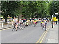
Ealing Skyride - cyclists on traffic-free streets
Ealing Skyride http://www.goskyride.com/location/ealing/ closed an 11km circuit of roads in Ealing and Hanwell to traffic, giving a safe ride for children and inexperienced cyclists. 13,000 cyclists took advantage of the opportunity. For other Skyrides on traffic-free streets see http://www.goskyride.com/ .
Image: © David Hawgood
Taken: 18 Jul 2010
0.07 miles
8
![Ealing houses [17]](https://s0.geograph.org.uk/geophotos/06/36/85/6368576_79d3fad5_120x120.jpg)
Ealing houses [17]
This fine pair of semi-detached houses at numbers 19 and 21 St Mary's Road was built circa 1840. Listed, grade II, with details at: https://historicengland.org.uk/listing/the-list/list-entry/1189467
Ealing is one of the seven major towns in the London Borough of Ealing. A rural village until communications with London got better with the improvements to the road to Oxford (later Uxbridge Road) in the 18th century and culminating with the coming of the railway in 1838. Ealing expanded greatly with suburban development during the 19th century and became known as the "Queen of the Suburbs" due to its greenery and because it was halfway between city and country. Ealing became a municipal borough in 1901. Growth continued throughout the 20th century and Ealing became part of a modern London borough in 1965.
Image: © Michael Dibb
Taken: 14 Sep 2019
0.08 miles
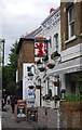
9
![Ealing buildings [19]](https://s1.geograph.org.uk/geophotos/06/36/85/6368577_b155f6b9_120x120.jpg)
Ealing buildings [19]
The very attractive Red Lion public house at number 13 St Mary's Road can trace its first publican back to 1825 although the existing building is later. Often used by the stars from Ealing Studios across the road.
Ealing is one of the seven major towns in the London Borough of Ealing. A rural village until communications with London got better with the improvements to the road to Oxford (later Uxbridge Road) in the 18th century and culminating with the coming of the railway in 1838. Ealing expanded greatly with suburban development during the 19th century and became known as the "Queen of the Suburbs" due to its greenery and because it was halfway between city and country. Ealing became a municipal borough in 1901. Growth continued throughout the 20th century and Ealing became part of a modern London borough in 1965.
Image: © Michael Dibb
Taken: 14 Sep 2019
0.08 miles