IMAGES TAKEN NEAR TO
Rowan Close, LONDON, W5 4YH
Introduction
This page details the photographs taken nearby to Rowan Close, W5 4YH by members of the Geograph project.
The Geograph project started in 2005 with the aim of publishing, organising and preserving representative images for every square kilometre of Great Britain, Ireland and the Isle of Man.

There are currently over 7.5m images from over14,400 individuals and you can help contribute to the project by visiting https://www.geograph.org.uk
Image Map
Images are licensed for reuse under creativecommons.org/licenses/by-sa/2.0
Notes
- Clicking on the map will re-center to the selected point.
- The higher the marker number, the further away the image location is from the centre of the postcode.
Image Listing (51 Images Found)
Images are licensed for reuse under creativecommons.org/licenses/by-sa/2.0
Image
Details
Distance
1
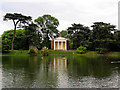
Gunnersbury Park
The pond and building are situated in the south eastern section of the grid square. This section of the park occupies about 40 percent of this grid square. The picture was taken from the south west side of the pond.
Image: © Pam Brophy
Taken: 10 May 2005
0.11 miles