IMAGES TAKEN NEAR TO
Grove Court, The Grove, LONDON, W5 3SJ
Introduction
This page details the photographs taken nearby to Grove Court, The Grove, W5 3SJ by members of the Geograph project.
The Geograph project started in 2005 with the aim of publishing, organising and preserving representative images for every square kilometre of Great Britain, Ireland and the Isle of Man.

There are currently over 7.5m images from over14,400 individuals and you can help contribute to the project by visiting https://www.geograph.org.uk
Image Map (Loading...)


Getting Data...Please wait
Leaflet Map data © OpenStreetMap
Images are licensed for reuse under creativecommons.org/licenses/by-sa/2.0
Notes
- Clicking on the map will re-center to the selected point.
- The higher the marker number, the further away the image location is from the centre of the postcode.
Image Listing (116 Images Found)
Images are licensed for reuse under creativecommons.org/licenses/by-sa/2.0
Image
Details
Distance
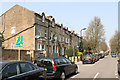
1
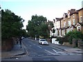
The eastern part of the street named "The Grove"
A row of residential houses with large front gardens, now used for off-street parking.
Image: © David Smith
Taken: 13 Jun 2011
0.01 miles
2
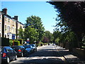
The Grove, Ealing
A pleasant tree-lined road leading to Ealing Common, which can be seen in the distance.
Image: © Rod Allday
Taken: 18 Aug 2012
0.01 miles
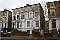
3
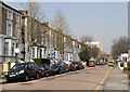
Windsor Road Ealing
Mature trees (and parked cars) line this residential street a few minutes walk from the stations.
Image: © David Smith
Taken: 13 Jun 2011
0.06 miles
4
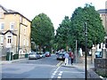
Windsor Road
A wide urban street with large semi-detached housing along its west side. In the distance is the spire of the Methodist Church which stands on the junction with The Mall.
Image: © Martin Addison
Taken: 23 Mar 2012
0.08 miles
5
Oxford Road
Unusual dormer windows on the terraced houses along this road.
Image: © Martin Addison
Taken: 23 Mar 2012
0.10 miles
6
Semi-detached houses on Windsor Road
There is an OS benchmark Image on the left hand half of the wall pier left of the tree growing in the pavement
Image: © Roger Templeman
Taken: 16 Nov 2015
0.11 miles
7
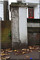
Benchmark on party wall pier of Nos. 28,30 Windsor Road
Ordnance Survey cut mark benchmark described on the Bench Mark Database at http://www.bench-marks.org.uk/bm71709
Image: © Roger Templeman
Taken: 16 Nov 2015
0.12 miles
8
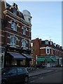
The Kings Arms inn
The inn is on the corner of "The Grove" and Western Road. The building opposite is dated 1894 in the inscription visible on the facade
Image: © David Smith
Taken: 13 Jun 2011
0.12 miles
9
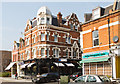
The Kings Arms
Located on the corner of The Grove and Western Road, the pub was built in 1897.
Image: © Martin Addison
Taken: 23 Mar 2012
0.12 miles
10
![Ealing houses [30]](https://s0.geograph.org.uk/geophotos/06/37/00/6370068_6f33a65b_120x120.jpg)
Ealing houses [30]
This long row contains numbers 6, 7, 8 and 9, The Common. Built circa 1840 with the division between the houses in the form of Doric pilasters. Listed, grade II, with details at: https://historicengland.org.uk/listing/the-list/list-entry/1358759
Ealing is one of the seven major towns in the London Borough of Ealing. A rural village until communications with London got better with the improvements to the road to Oxford (later Uxbridge Road) in the 18th century and culminating with the coming of the railway in 1838. Ealing expanded greatly with suburban development during the 19th century and became known as the "Queen of the Suburbs" due to its greenery and because it was halfway between city and country. Ealing became a municipal borough in 1901. Growth continued throughout the 20th century and Ealing became part of a modern London borough in 1965.
Image: © Michael Dibb
Taken: 14 Sep 2019
0.13 miles