IMAGES TAKEN NEAR TO
Tring Avenue, LONDON, W5 3QB
Introduction
This page details the photographs taken nearby to Tring Avenue, W5 3QB by members of the Geograph project.
The Geograph project started in 2005 with the aim of publishing, organising and preserving representative images for every square kilometre of Great Britain, Ireland and the Isle of Man.

There are currently over 7.5m images from over14,400 individuals and you can help contribute to the project by visiting https://www.geograph.org.uk
Image Map (Loading...)


Getting Data...Please wait
Leaflet Map data © OpenStreetMap
Images are licensed for reuse under creativecommons.org/licenses/by-sa/2.0
Notes
- Clicking on the map will re-center to the selected point.
- The higher the marker number, the further away the image location is from the centre of the postcode.
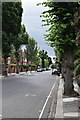
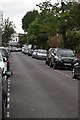
Image Listing (52 Images Found)
Images are licensed for reuse under creativecommons.org/licenses/by-sa/2.0
Image
Details
Distance
2
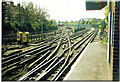
Ealing Common Station
Storage, and Workshop, Roads. For more information on the London Underground depot see http://en.wikipedia.org/wiki/Ealing_Common_Depot
Image: © Ron Hann
Taken: Unknown
0.07 miles
4
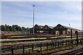
Ealing Common depot
The north entrance to Ealing Common underground depot
Image: © Andrew Abbott
Taken: 24 Sep 2016
0.07 miles
6
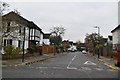
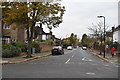
Tring Avenue
From the junction with Leopold Road
Image: © John Myers
Taken: 4 Aug 2015
0.12 miles
8

Ealing Common Station
Electric unit entering traffic from the adjacent depot http://en.wikipedia.org/wiki/Ealing_Common_Depot .
Image: © Ron Hann
Taken: Unknown
0.14 miles

10
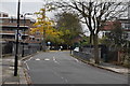
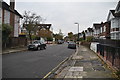
Woodgrange Road
No parking spaces in this cul-de-sac close to Ealing Common station
Image: © John Myers
Taken: 4 Aug 2015
0.15 miles