IMAGES TAKEN NEAR TO
St. Marks Road, LONDON, W5 3JF
Introduction
This page details the photographs taken nearby to St. Marks Road, W5 3JF by members of the Geograph project.
The Geograph project started in 2005 with the aim of publishing, organising and preserving representative images for every square kilometre of Great Britain, Ireland and the Isle of Man.

There are currently over 7.5m images from over14,400 individuals and you can help contribute to the project by visiting https://www.geograph.org.uk
Image Map (Loading...)


Getting Data...Please wait
Leaflet Map data © OpenStreetMap
Images are licensed for reuse under creativecommons.org/licenses/by-sa/2.0
Notes
- Clicking on the map will re-center to the selected point.
- The higher the marker number, the further away the image location is from the centre of the postcode.
Image Listing (55 Images Found)
Images are licensed for reuse under creativecommons.org/licenses/by-sa/2.0
Image
Details
Distance
1
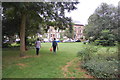
Grange Park, Ealing
Half way along Grange Park is this attractive triangle of green.
Image: © Trevor Harris
Taken: 31 Jul 2012
0.08 miles
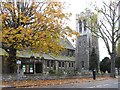
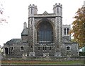
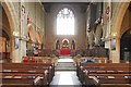
5
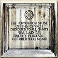
All Saints, Elm Grove Road, London W5 - Foundation stone
Image: © John Salmon
Taken: 3 Nov 2004
0.13 miles