IMAGES TAKEN NEAR TO
The Ridings, LONDON, W5 3DP
Introduction
This page details the photographs taken nearby to The Ridings, W5 3DP by members of the Geograph project.
The Geograph project started in 2005 with the aim of publishing, organising and preserving representative images for every square kilometre of Great Britain, Ireland and the Isle of Man.

There are currently over 7.5m images from over14,400 individuals and you can help contribute to the project by visiting https://www.geograph.org.uk
Image Map
Images are licensed for reuse under creativecommons.org/licenses/by-sa/2.0
Notes
- Clicking on the map will re-center to the selected point.
- The higher the marker number, the further away the image location is from the centre of the postcode.
Image Listing (88 Images Found)
Images are licensed for reuse under creativecommons.org/licenses/by-sa/2.0
Image
Details
Distance
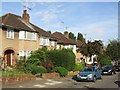
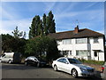
1
The Ridings, W5
A fairly up-market residential area.
Image: © Robin Webster
Taken: 6 Oct 2012
0.03 miles
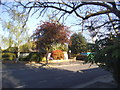
2
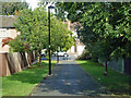
Path from The Ridings to Ashbourne Road, Haymills estate
Image: © Robin Webster
Taken: 6 Oct 2012
0.05 miles
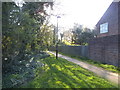
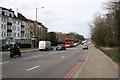
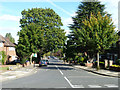
3
Ashbourne Road
This is on the walk uphill along Heathcroft from Park Royal Underground station. Ashbourne Road dips down ahead to give views across to Horsenden Hill and Harrow on the Hill.
Image: © Marathon
Taken: 8 Oct 2014
0.08 miles
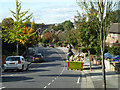
4
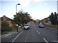
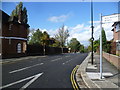
Heathcroft, W5
Looking downhill from the junction with The Ridings.
Image: © Robin Webster
Taken: 6 Oct 2012
0.09 miles