IMAGES TAKEN NEAR TO
Connell Crescent, LONDON, W5 3BL
Introduction
This page details the photographs taken nearby to Connell Crescent, W5 3BL by members of the Geograph project.
The Geograph project started in 2005 with the aim of publishing, organising and preserving representative images for every square kilometre of Great Britain, Ireland and the Isle of Man.

There are currently over 7.5m images from over14,400 individuals and you can help contribute to the project by visiting https://www.geograph.org.uk
Image Map (Loading...)


Getting Data...Please wait
Leaflet Map data © OpenStreetMap
Images are licensed for reuse under creativecommons.org/licenses/by-sa/2.0
Notes
- Clicking on the map will re-center to the selected point.
- The higher the marker number, the further away the image location is from the centre of the postcode.
Image Listing (103 Images Found)
Images are licensed for reuse under creativecommons.org/licenses/by-sa/2.0
Image
Details
Distance
3
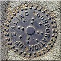
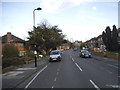
Metal hole cover, Western Avenue, W5
Ealing became a local government district in 1863, and an urban district in 1894 . In 1901 it was granted a charter of incorporation to become the first municipal borough in Middlesex. The urban district council was replaced by a corporation consisting of a mayor, 6 aldermen and 18 councillors. In 1965 (under the London Government Act 1963) the municipal borough was abolished and its former area transferred to Greater London and combined with the Municipal Borough of Acton and the Municipal Borough of Southall to form the present-day London Borough of Ealing. For further info see https://en.wikipedia.org/wiki/Municipal_Borough_of_Ealing and https://en.wikipedia.org/wiki/London_Borough_of_Ealing .
Image: © Mike Quinn
Taken: 5 Jul 2017
0.03 miles
4
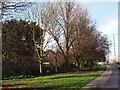
Green corridor by Western Avenue
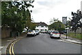
The area of grass and trees between the major road and houses provides a buffer zone to reduce noise and pollution. Ealing Council's stated plan to continue this along other parts of the A40 saved residents from a bus garage proposed by Transport for London at Gipsy Corner. The photo shows the path and cycle track beside the A40; Hanger Lane Gyratory with the A40 in an underpass is on the far right.
Image: © David Hawgood
Taken: 19 Jan 2007
0.04 miles

8
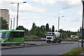
"Games traffic only in games lane" Olympics sign
The Olympics road network route to Wembley Stadium comes along the A40 Western Avenue, then at this point goes onto a slip road, round the Hanger Lane Gyratory, and up the A406 North Circular. This sign shows that one of the two lanes of the slip road is restricted to games traffic. The restrictions were only applied for limited periods when practice or matches were imminent.
Image: © David Hawgood
Taken: 27 Jul 2012
0.07 miles
9
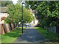
Path from The Ridings to Ashbourne Road, Haymills estate
Image: © Robin Webster
Taken: 6 Oct 2012
0.07 miles