IMAGES TAKEN NEAR TO
Connell Crescent, LONDON, W5 3BJ
Introduction
This page details the photographs taken nearby to Connell Crescent, W5 3BJ by members of the Geograph project.
The Geograph project started in 2005 with the aim of publishing, organising and preserving representative images for every square kilometre of Great Britain, Ireland and the Isle of Man.

There are currently over 7.5m images from over14,400 individuals and you can help contribute to the project by visiting https://www.geograph.org.uk
Image Map (Loading...)


Getting Data...Please wait
Leaflet Map data © OpenStreetMap
Images are licensed for reuse under creativecommons.org/licenses/by-sa/2.0
Notes
- Clicking on the map will re-center to the selected point.
- The higher the marker number, the further away the image location is from the centre of the postcode.
Image Listing (113 Images Found)
Images are licensed for reuse under creativecommons.org/licenses/by-sa/2.0
Image
Details
Distance
2
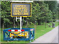
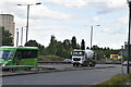
"Games traffic only in games lane" Olympics sign
The Olympics road network route to Wembley Stadium comes along the A40 Western Avenue, then at this point goes onto a slip road, round the Hanger Lane Gyratory, and up the A406 North Circular. This sign shows that one of the two lanes of the slip road is restricted to games traffic. The restrictions were only applied for limited periods when practice or matches were imminent.
Image: © David Hawgood
Taken: 27 Jul 2012
0.03 miles
4
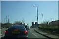
Western Avenue, W5
The slip road from the Hangar Lane roundabout going towards the A40 Western Avenue. The flat roofed building centre-right of the picture is Park Royal underground station, in the next square.
Image: © Phillip Perry
Taken: 19 Mar 2011
0.04 miles
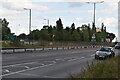
7
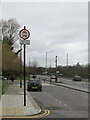
Traffic restriction stops Western Avenue evening rat run
The road sign in Connell Crescent prohibits motor traffic from 3pm to 7 pm on Monday to Friday. The inner lane of Western Avenue here is a slip lane to turn into the North Circular, and it often jams up in the evening rush hour. Traffic usewd to escape by using the narrow residential Connell Crescent which exits onto the North Circular. From 2015 there were many appeals from motorists caught by traffic cameras, but most appeals were dismissed.
Image: © David Hawgood
Taken: 19 Feb 2021
0.06 miles
9
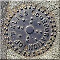
Metal hole cover, Western Avenue, W5
Ealing became a local government district in 1863, and an urban district in 1894 . In 1901 it was granted a charter of incorporation to become the first municipal borough in Middlesex. The urban district council was replaced by a corporation consisting of a mayor, 6 aldermen and 18 councillors. In 1965 (under the London Government Act 1963) the municipal borough was abolished and its former area transferred to Greater London and combined with the Municipal Borough of Acton and the Municipal Borough of Southall to form the present-day London Borough of Ealing. For further info see https://en.wikipedia.org/wiki/Municipal_Borough_of_Ealing and https://en.wikipedia.org/wiki/London_Borough_of_Ealing .
Image: © Mike Quinn
Taken: 5 Jul 2017
0.08 miles
10
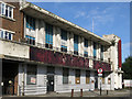
(The former) Joices Pub and Restaurant, Hanger Green, W5
It's still possible to read "Joices" on the vertical maroon strip on the far right of the building, but the lettering on the horizontal strip between the ground and first floors is undecipherable. The building in happier days is shown in Image (photographed by Russell Trebor).
Image: © Mike Quinn
Taken: 5 Jul 2017
0.09 miles