IMAGES TAKEN NEAR TO
Mount Park Crescent, LONDON, W5 2RR
Introduction
This page details the photographs taken nearby to Mount Park Crescent, W5 2RR by members of the Geograph project.
The Geograph project started in 2005 with the aim of publishing, organising and preserving representative images for every square kilometre of Great Britain, Ireland and the Isle of Man.

There are currently over 7.5m images from over14,400 individuals and you can help contribute to the project by visiting https://www.geograph.org.uk
Image Map (Loading...)


Getting Data...Please wait
Leaflet Map data © OpenStreetMap
Images are licensed for reuse under creativecommons.org/licenses/by-sa/2.0
Notes
- Clicking on the map will re-center to the selected point.
- The higher the marker number, the further away the image location is from the centre of the postcode.
Image Listing (148 Images Found)
Images are licensed for reuse under creativecommons.org/licenses/by-sa/2.0
Image
Details
Distance
1
![Ealing houses [32]](https://s2.geograph.org.uk/geophotos/06/37/00/6370098_35e0899c_120x120.jpg)
Ealing houses [32]
Numbers 13 and 14 Mount Park Road are a pair of substantial semi-detached houses with wonderful detailing.
Ealing is one of the seven major towns in the London Borough of Ealing. A rural village until communications with London got better with the improvements to the road to Oxford (later Uxbridge Road) in the 18th century and culminating with the coming of the railway in 1838. Ealing expanded greatly with suburban development during the 19th century and became known as the "Queen of the Suburbs" due to its greenery and because it was halfway between city and country. Ealing became a municipal borough in 1901. Growth continued throughout the 20th century and Ealing became part of a modern London borough in 1965.
Image: © Michael Dibb
Taken: 14 Sep 2019
0.06 miles
2
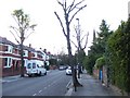
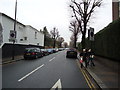
Mount Park Road
Looking north with a view to the spire of St Andrews URC building
Image: © David Smith
Taken: 13 Jun 2011
0.08 miles
3
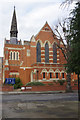
St Andrew's United Reformed Church, Ealing
This church, on the corner of Mount Park Road and Aston Road just to the north of Ealing town centre, was opened in 1887. The style was described as '13th century gothic' and it was capable of accommodating 550 worshippers.
Image: © Stephen McKay
Taken: 6 Mar 2018
0.08 miles
4
![Ealing buildings [43]](https://s3.geograph.org.uk/geophotos/06/37/00/6370095_de26a5bb_120x120.jpg)
Ealing buildings [43]
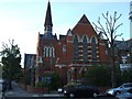
St Andrew's United Reformed Church is at the junction of Aston Road and Mount Park Road. Originally Presbyterian it became United Reformed in 1972. Built in 1887 and enlarged from 550 seats to 800 seats in the 1890s.
Ealing is one of the seven major towns in the London Borough of Ealing. A rural village until communications with London got better with the improvements to the road to Oxford (later Uxbridge Road) in the 18th century and culminating with the coming of the railway in 1838. Ealing expanded greatly with suburban development during the 19th century and became known as the "Queen of the Suburbs" due to its greenery and because it was halfway between city and country. Ealing became a municipal borough in 1901. Growth continued throughout the 20th century and Ealing became part of a modern London borough in 1965.
Image: © Michael Dibb
Taken: 14 Sep 2019
0.08 miles
5
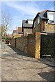
Walls on east side of Mount Park Road
The walls belong to 'The Studio' and 'Yambacoona'
Image: © Roger Templeman
Taken: 1 Apr 2016
0.08 miles
6
St Andrews URC building
St Andrews United Reformed Church building is on the corner of Mount Park road and Aston Road
Image: © David Smith
Taken: 13 Jun 2011
0.08 miles
8
![Ealing houses [33]](https://s2.geograph.org.uk/geophotos/06/37/01/6370106_d458ac51_120x120.jpg)
Ealing houses [33]
Construction of a 30 apartment block is taking place in Mount Park Road. The site is that of Moullin House, a 60 bed Methodist Hostel which was demolished in 2017. First sold in 2011 to the Ealing and West London College for student accommodation the site was later sold to a development company.
Ealing is one of the seven major towns in the London Borough of Ealing. A rural village until communications with London got better with the improvements to the road to Oxford (later Uxbridge Road) in the 18th century and culminating with the coming of the railway in 1838. Ealing expanded greatly with suburban development during the 19th century and became known as the "Queen of the Suburbs" due to its greenery and because it was halfway between city and country. Ealing became a municipal borough in 1901. Growth continued throughout the 20th century and Ealing became part of a modern London borough in 1965.
Image: © Michael Dibb
Taken: 14 Sep 2019
0.10 miles
9
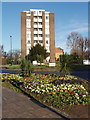
Flower bed, Haven Green
A good colourful display of bedding plants at the beginning of February. Beyond is the roundabout with Madeley Road to the right, then flats at the junction of Mount Park Road and Haven Green.
Image: © David Hawgood
Taken: 4 Feb 2008
0.11 miles
10
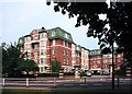
Haven Green Court
Luxury mansion style apartments built 1937-8.
Image: © Des Blenkinsopp
Taken: 25 Jun 2013
0.11 miles