IMAGES TAKEN NEAR TO
The Mall, LONDON, W5 2PL
Introduction
This page details the photographs taken nearby to The Mall, W5 2PL by members of the Geograph project.
The Geograph project started in 2005 with the aim of publishing, organising and preserving representative images for every square kilometre of Great Britain, Ireland and the Isle of Man.

There are currently over 7.5m images from over14,400 individuals and you can help contribute to the project by visiting https://www.geograph.org.uk
Image Map (Loading...)


Getting Data...Please wait
Leaflet Map data © OpenStreetMap
Images are licensed for reuse under creativecommons.org/licenses/by-sa/2.0
Notes
- Clicking on the map will re-center to the selected point.
- The higher the marker number, the further away the image location is from the centre of the postcode.
Image Listing (290 Images Found)
Images are licensed for reuse under creativecommons.org/licenses/by-sa/2.0
Image
Details
Distance
1
![Ealing buildings [35]](https://s1.geograph.org.uk/geophotos/06/36/92/6369289_cf39c070_120x120.jpg)
Ealing buildings [35]
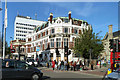
Partly hidden behind greenery is a fine French Gothic style 1874 building that was Ealing's first town hall. Now home to a branch of Natwest Bank, the building is listed, grade II, with details at: https://historicengland.org.uk/listing/the-list/list-entry/1189300 For another view of the building see Image
Ealing is one of the seven major towns in the London Borough of Ealing. A rural village until communications with London got better with the improvements to the road to Oxford (later Uxbridge Road) in the 18th century and culminating with the coming of the railway in 1838. Ealing expanded greatly with suburban development during the 19th century and became known as the "Queen of the Suburbs" due to its greenery and because it was halfway between city and country. Ealing became a municipal borough in 1901. Growth continued throughout the 20th century and Ealing became part of a modern London borough in 1965.
Image: © Michael Dibb
Taken: 14 Sep 2019
0.01 miles
2
![Ealing buildings [36]](https://s3.geograph.org.uk/geophotos/06/36/92/6369291_b655e0dd_120x120.jpg)
Ealing buildings [36]
Partly hidden behind greenery is a fine French Gothic style 1874 building that was Ealing's first town hall. Now home to a branch of Natwest Bank, the building is listed, grade II, with details at: https://historicengland.org.uk/listing/the-list/list-entry/1189300 For another view of the building see Image
Ealing is one of the seven major towns in the London Borough of Ealing. A rural village until communications with London got better with the improvements to the road to Oxford (later Uxbridge Road) in the 18th century and culminating with the coming of the railway in 1838. Ealing expanded greatly with suburban development during the 19th century and became known as the "Queen of the Suburbs" due to its greenery and because it was halfway between city and country. Ealing became a municipal borough in 1901. Growth continued throughout the 20th century and Ealing became part of a modern London borough in 1965.
Image: © Michael Dibb
Taken: 14 Sep 2019
0.01 miles
3
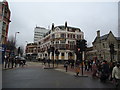
'He Ow Hue', Ealing (closed)
Of course The Town House. When built in 1929, it was, or at least housed, The Feathers Restaurant, according to the inscription (with feathers) above. According to the agent's sign it has been sold as a 'Mixed use development opportunity'.
Image: © Robin Webster
Taken: 6 Oct 2012
0.01 miles
4
![Ealing buildings [34]](https://s3.geograph.org.uk/geophotos/06/36/92/6369283_e686eab9_120x120.jpg)
Ealing buildings [34]
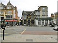
This fine 1929 building was originally home to The Feathers Restaurant and later The Town House public house. The pub closed in 2008, the building underwent restoration and is now has a bank on the ground floor with renovated apartments above. It is pleasing that the building looks in better condition than it did in Stacey Harris' image of 2010 Image or in Robin Webster's image of 2012 Image
Ealing is one of the seven major towns in the London Borough of Ealing. A rural village until communications with London got better with the improvements to the road to Oxford (later Uxbridge Road) in the 18th century and culminating with the coming of the railway in 1838. Ealing expanded greatly with suburban development during the 19th century and became known as the "Queen of the Suburbs" due to its greenery and because it was halfway between city and country. Ealing became a municipal borough in 1901. Growth continued throughout the 20th century and Ealing became part of a modern London borough in 1965.
Image: © Michael Dibb
Taken: 14 Sep 2019
0.01 miles
6

Benchmark on Halifax Building Society branch
Ordnance Survey cut mark benchmark described on the Bench Mark Database at http://www.bench-marks.org.uk/bm71753
Image: © Roger Templeman
Taken: 16 Nov 2015
0.03 miles
7
Ealing, North Star
Town centre pub on Broadway; three areas, with a covered outdoors passage. Bar right, eating and drinking left and back; background music, exposed brickwork and dark colours. Cask ales on offer at my visit: Dark Star Hophead, St Austell Tribute.
Image: © Mike Faherty
Taken: 2 Apr 2016
0.03 miles
10
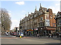
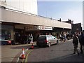
Ealing - shops on The Broadway
The nearest shop is prominently inscribed Edwards Furnishing with a date on the end wall of 1902.
Image: © Peter Whatley
Taken: 2 Apr 2012
0.03 miles