IMAGES TAKEN NEAR TO
Hanger Lane, LONDON, W5 2JH
Introduction
This page details the photographs taken nearby to Hanger Lane, W5 2JH by members of the Geograph project.
The Geograph project started in 2005 with the aim of publishing, organising and preserving representative images for every square kilometre of Great Britain, Ireland and the Isle of Man.

There are currently over 7.5m images from over14,400 individuals and you can help contribute to the project by visiting https://www.geograph.org.uk
Image Map (Loading...)


Getting Data...Please wait
Leaflet Map data © OpenStreetMap
Images are licensed for reuse under creativecommons.org/licenses/by-sa/2.0
Notes
- Clicking on the map will re-center to the selected point.
- The higher the marker number, the further away the image location is from the centre of the postcode.
Image Listing (109 Images Found)
Images are licensed for reuse under creativecommons.org/licenses/by-sa/2.0
Image
Details
Distance
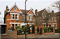
1
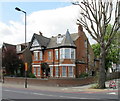
House on Hanger Lane
At the corner of Woodville Gardens.
Image: © David Hawgood
Taken: 30 Apr 2010
0.02 miles
2
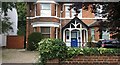
House on Hanger Lane, Ealing
The Victorian houses opposite were demolished a few years ago and were replaced by Victorian style flats. Hardly an improvement.
Image: © David Howard
Taken: 16 Jul 2016
0.02 miles
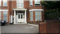
5
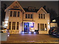
The Momo hotel and restaurant, North Ealing
On the North Circular Road
Image: © David Howard
Taken: 16 Nov 2013
0.03 miles
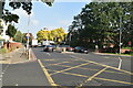
6
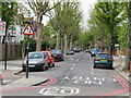
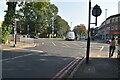
Woodville Gardens with 20 mph speed limit
Some residential areas in Ealing have 20 mph speed limits. View across Hanger Lane, the North Circular A406.
Image: © David Hawgood
Taken: 30 Apr 2010
0.03 miles
9
Madeley Rd reaches The North Circular Road
Image: © N Chadwick
Taken: 9 Oct 2021
0.06 miles
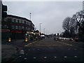
10
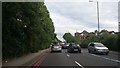
The North Circular Road, Ealing
Officially considered Britain's worst road, it is London's only outer ring road and is a mixture between modern dual carriageway and traditional two lane A road, and everything in between. During the weekdays it is usually gridlocked in many parts.
Image: © David Howard
Taken: 16 Jul 2016
0.06 miles