IMAGES TAKEN NEAR TO
Castlebar Road, LONDON, W5 2DS
Introduction
This page details the photographs taken nearby to Castlebar Road, W5 2DS by members of the Geograph project.
The Geograph project started in 2005 with the aim of publishing, organising and preserving representative images for every square kilometre of Great Britain, Ireland and the Isle of Man.

There are currently over 7.5m images from over14,400 individuals and you can help contribute to the project by visiting https://www.geograph.org.uk
Image Map (Loading...)


Getting Data...Please wait
Leaflet Map data © OpenStreetMap
Images are licensed for reuse under creativecommons.org/licenses/by-sa/2.0
Notes
- Clicking on the map will re-center to the selected point.
- The higher the marker number, the further away the image location is from the centre of the postcode.
Image Listing (149 Images Found)
Images are licensed for reuse under creativecommons.org/licenses/by-sa/2.0
Image
Details
Distance
1
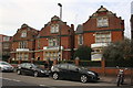
Harvington Prep School for Girls, Castlebar Road
There is an OS benchmark Image on the wall pier between the motorcycle and car.
Image: © Roger Templeman
Taken: 16 Nov 2015
0.01 miles
2
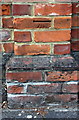
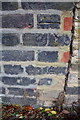
Benchmark on wall of Harvington Prep School
Ordnance Survey cut mark benchmark described on the Bench Mark Database at http://www.bench-marks.org.uk/bm71876
Image: © Roger Templeman
Taken: 16 Nov 2015
0.01 miles
3
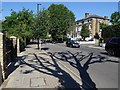
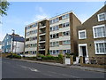
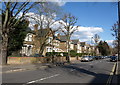
Castlebar Road, Ealing
A quiet Sunday monring on Castlebar Road in Ealing.
Image: © Philip Halling
Taken: 15 Jul 2018
0.04 miles
4
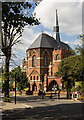
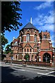
Ealing : Haven Green Baptist Church
The church in 1881, built to a design by architect J. Wallis Chapman. Find out more at this https://www.archiseek.com/2009/1880-haven-green-chape-ealing-london/,
Image: © Jim Osley
Taken: 17 Aug 2023
0.08 miles
6
Haven Green Baptist Church
Castlebar Road
Image: © John Myers
Taken: 4 Aug 2015
0.09 miles
7
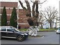
Oak Tree
Oak Tree in middle of Carlton Road
Image: © Alex McGregor
Taken: 10 Feb 2010
0.10 miles
8
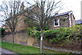
Carlton Road houses seen from Longfield Walk
There is an OS benchmark Image on the house wall of #43 Carlton Road at its junction with the house's garden side wall
Image: © Roger Templeman
Taken: 16 Nov 2015
0.10 miles
9
Benchmark on Longfield Walk face of #43 Carlton Road
Ordnance Survey cut mark benchmark described on the Bench Mark Database at http://www.bench-marks.org.uk/bm71765
Image: © Roger Templeman
Taken: 16 Nov 2015
0.11 miles
10
Gordon Road, Ealing
A residential road, here composed of detached houses, running parallel to the main Paddington railway line. Some recently pollarded trees line it.
Image: © Derek Harper
Taken: 19 Mar 2012
0.11 miles