IMAGES TAKEN NEAR TO
Mount Avenue, LONDON, W5 1TH
Introduction
This page details the photographs taken nearby to Mount Avenue, W5 1TH by members of the Geograph project.
The Geograph project started in 2005 with the aim of publishing, organising and preserving representative images for every square kilometre of Great Britain, Ireland and the Isle of Man.

There are currently over 7.5m images from over14,400 individuals and you can help contribute to the project by visiting https://www.geograph.org.uk
Image Map
Images are licensed for reuse under creativecommons.org/licenses/by-sa/2.0
Notes
- Clicking on the map will re-center to the selected point.
- The higher the marker number, the further away the image location is from the centre of the postcode.
Image Listing (53 Images Found)
Images are licensed for reuse under creativecommons.org/licenses/by-sa/2.0
Image
Details
Distance
1
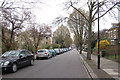
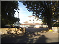
Mount Avenue, Ealing, W5
View taken a few metres south of junction with Castlebar Road.
Image: © MrC
Taken: 31 Mar 2009
0.04 miles
2
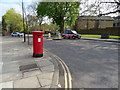
Mount Avenue, Ealing
Showing position of Postbox No. W5 13.
See Image] for postbox.
Image: © JThomas
Taken: 13 Apr 2019
0.06 miles
3
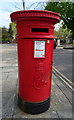
Edward VII postbox on Mount Avenue, Ealing
Postbox No. W5 13.
See Image] for context.
Image: © JThomas
Taken: 13 Apr 2019
0.07 miles
4
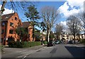
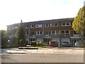
Castlebar Park, Ealing
Further southeast along the residential road shown in Image, with blocks of flats on the left.
Image: © Derek Harper
Taken: 19 Mar 2012
0.08 miles
6
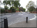
Castlebar Road at the junction of Montpelier Road
Image: © David Howard
Taken: 9 May 2015
0.14 miles
7
![Ealing buildings [46]](https://s0.geograph.org.uk/geophotos/06/37/07/6370748_6f500022_120x120.jpg)
Ealing buildings [46]
Part of the Benedictine Roman Catholic school founded following the arrival of Benedictine monks into Ealing in 1897 to found the first Benedictine Abbey in London since the Reformation. Originally a school for boys it is now fully co-educationalist. A number of former teachers at the school have been jailed for child abuse.
Ealing is one of the seven major towns in the London Borough of Ealing. A rural village until communications with London got better with the improvements to the road to Oxford (later Uxbridge Road) in the 18th century and culminating with the coming of the railway in 1838. Ealing expanded greatly with suburban development during the 19th century and became known as the "Queen of the Suburbs" due to its greenery and because it was halfway between city and country. Ealing became a municipal borough in 1901. Growth continued throughout the 20th century and Ealing became part of a modern London borough in 1965.
Image: © Michael Dibb
Taken: 14 Sep 2019
0.15 miles
9
Zebra crossing on Castlebar Road, Ealing
Image: © David Howard
Taken: 9 May 2015
0.16 miles
10
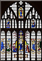
St Benedict's Ealing Abbey, Charlbury Grove, London W5 - Window
Situated in south transept
Image: © John Salmon
Taken: 12 Mar 2010
0.17 miles