IMAGES TAKEN NEAR TO
Lanark Close, LONDON, W5 1SN
Introduction
This page details the photographs taken nearby to Lanark Close, W5 1SN by members of the Geograph project.
The Geograph project started in 2005 with the aim of publishing, organising and preserving representative images for every square kilometre of Great Britain, Ireland and the Isle of Man.

There are currently over 7.5m images from over14,400 individuals and you can help contribute to the project by visiting https://www.geograph.org.uk
Image Map
Images are licensed for reuse under creativecommons.org/licenses/by-sa/2.0
Notes
- Clicking on the map will re-center to the selected point.
- The higher the marker number, the further away the image location is from the centre of the postcode.
Image Listing (44 Images Found)
Images are licensed for reuse under creativecommons.org/licenses/by-sa/2.0
Image
Details
Distance
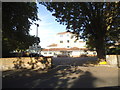
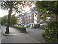
3
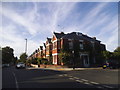
Castlebar Park, Ealing
Further southeast along the residential road shown in Image, with blocks of flats on the left.
Image: © Derek Harper
Taken: 19 Mar 2012
0.11 miles
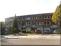
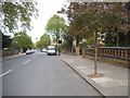
4
Mount Avenue, Ealing, W5
View taken a few metres south of junction with Castlebar Road.
Image: © MrC
Taken: 31 Mar 2009
0.12 miles
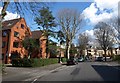
5
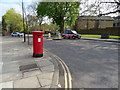
Mount Avenue, Ealing
Showing position of Postbox No. W5 13.
See Image] for postbox.
Image: © JThomas
Taken: 13 Apr 2019
0.14 miles
6
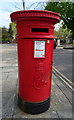
Edward VII postbox on Mount Avenue, Ealing
Postbox No. W5 13.
See Image] for context.
Image: © JThomas
Taken: 13 Apr 2019
0.15 miles
7
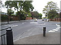
Woodfield Road at the junction of Woodfield Crescent
Image: © David Howard
Taken: 11 Jul 2015
0.16 miles
8
Castlebar Road at the junction of Montpelier Road
Image: © David Howard
Taken: 9 May 2015
0.17 miles
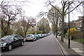
10
Montpelier Road, Ealing
St Benedict's School is behind the wall on the right
Image: © David Howard
Taken: 9 May 2015
0.18 miles