IMAGES TAKEN NEAR TO
West Gate, LONDON, W5 1BS
Introduction
This page details the photographs taken nearby to West Gate, W5 1BS by members of the Geograph project.
The Geograph project started in 2005 with the aim of publishing, organising and preserving representative images for every square kilometre of Great Britain, Ireland and the Isle of Man.

There are currently over 7.5m images from over14,400 individuals and you can help contribute to the project by visiting https://www.geograph.org.uk
Image Map
Images are licensed for reuse under creativecommons.org/licenses/by-sa/2.0
Notes
- Clicking on the map will re-center to the selected point.
- The higher the marker number, the further away the image location is from the centre of the postcode.
Image Listing (120 Images Found)
Images are licensed for reuse under creativecommons.org/licenses/by-sa/2.0
Image
Details
Distance
3
![Hanger Hill [7]](https://s2.geograph.org.uk/geophotos/07/41/07/7410758_4dd06340_120x120.jpg)
Hanger Hill [7]
The London Underground Central Line rails leading to and from West Ruislip. Seen from the platform at Hanger Lane station.
Hanger Hill is an area of the London Borough of Ealing. It is famous, or perhaps infamous, for the Hanger Lane gyratory, a complex and busy road junction where the North Circular Road (A406) crosses Western Avenue (A40). The gyratory incorporates Hanger Lane Station on the London Underground.
Image: © Michael Dibb
Taken: 5 Feb 2023
0.04 miles
5
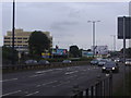
Western Avenue (A40) at the eastbound Hanger Lane exit
Image: © Peter Whatley
Taken: 1 Apr 2012
0.05 miles
6
Westway before the North Circular junction at Hanger Lane
Image: © David Howard
Taken: 6 Jun 2009
0.05 miles
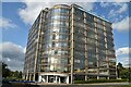
7
![Hanger Hill [2]](https://s1.geograph.org.uk/geophotos/07/41/06/7410637_7bdc3d10_120x120.jpg)
Hanger Hill [2]
Seen from Hanger Lane, West Gate provides access to a complex of offices and warehouses.
Hanger Hill is an area of the London Borough of Ealing. It is famous, or perhaps infamous, for the Hanger Lane gyratory, a complex and busy road junction where the North Circular Road (A406) crosses Western Avenue (A40). The gyratory incorporates Hanger Lane Station on the London Underground.
Image: © Michael Dibb
Taken: 5 Feb 2023
0.05 miles
8
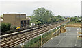
Westward on the GWR Birmingham main line and LT Central Line to site of Brentham Halt
View westward from above Hanger Lane station (behind camera), towards Birmingham via Bicester on the main line and West Ruislip on the Central Line - which parallels the ex-GWR line on the Down (far) side. Brentham Halt had been ahead about 200 yards and was closed from 30/6/47 when the GWR Westbourne Park - Northolt auto-train service ceased on the initiation of the Central Line service as far as Greenford, which was extended to West Ruislip on 21/11/48.
Image: © Ben Brooksbank
Taken: 18 May 1986
0.05 miles
9
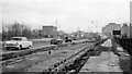
East on the A40 to Hanger Lane during construction of the infamous Gyratory
Burgeoning road traffic in the late 1950s necessitated the construction of the complex junction of the main A40 Western Avenue from London with the North Circular Road at Hanger Lane, but the Gyratory has never kept up with requirements.
Image: © Ben Brooksbank
Taken: 28 Nov 1959
0.06 miles
10
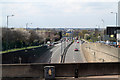
Western Avenue
The A40 seen from the top deck of an 83 bus on the Hanger Lane Gyratory System.
Image: © Martin Addison
Taken: 6 Apr 2012
0.07 miles