IMAGES TAKEN NEAR TO
Addison Terrace, Chiswick Road, LONDON, W4 5RF
Introduction
This page details the photographs taken nearby to Addison Terrace, Chiswick Road, W4 5RF by members of the Geograph project.
The Geograph project started in 2005 with the aim of publishing, organising and preserving representative images for every square kilometre of Great Britain, Ireland and the Isle of Man.

There are currently over 7.5m images from over14,400 individuals and you can help contribute to the project by visiting https://www.geograph.org.uk
Image Map
Images are licensed for reuse under creativecommons.org/licenses/by-sa/2.0
Notes
- Clicking on the map will re-center to the selected point.
- The higher the marker number, the further away the image location is from the centre of the postcode.
Image Listing (262 Images Found)
Images are licensed for reuse under creativecommons.org/licenses/by-sa/2.0
Image
Details
Distance
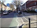
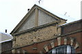
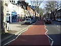
6
Connolly's, Chiswick High Road
A glance up at the pediment http://www.geograph.org.uk/photo/2205576 shows that this pub was originally named The Robin Hood.
Image: © Alan Murray-Rust
Taken: 19 Dec 2010
0.05 miles
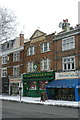
7
The Robin Hood
A relic of an earlier name for what is now called Connolly's http://www.geograph.org.uk/photo/2205568 .
Image: © Alan Murray-Rust
Taken: 19 Dec 2010
0.05 miles
8
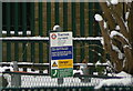
Acton Lane Junction
Notice detailing the change of ownership between London Underground Ltd and Network Rail - see http://www.geograph.org.uk/photo/2205607 .
Image: © Alan Murray-Rust
Taken: 19 Dec 2010
0.05 miles
10
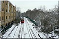
Acton Lane Junction - but not a point in sight
Many years ago, a line did indeed diverge to the right at this point, making the east side of Gunnersbury Triangle, but even so this is a junction. The gap in the conductor rails indicates the change of ownership between London Underground Limited and Network Rail, http://www.geograph.org.uk/photo/2205640 and there are plenty of other instances from the past history of British railway companies where an end-on meet like this was named as a junction.
Image: © Alan Murray-Rust
Taken: 19 Dec 2010
0.05 miles