IMAGES TAKEN NEAR TO
Ivy Crescent, LONDON, W4 5NG
Introduction
This page details the photographs taken nearby to Ivy Crescent, W4 5NG by members of the Geograph project.
The Geograph project started in 2005 with the aim of publishing, organising and preserving representative images for every square kilometre of Great Britain, Ireland and the Isle of Man.

There are currently over 7.5m images from over14,400 individuals and you can help contribute to the project by visiting https://www.geograph.org.uk
Image Map
Images are licensed for reuse under creativecommons.org/licenses/by-sa/2.0
Notes
- Clicking on the map will re-center to the selected point.
- The higher the marker number, the further away the image location is from the centre of the postcode.
Image Listing (227 Images Found)
Images are licensed for reuse under creativecommons.org/licenses/by-sa/2.0
Image
Details
Distance
1
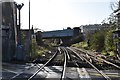
Piccadilly Line Bridge over The North London Line
Image: © N Chadwick
Taken: 15 Dec 2019
0.04 miles
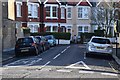
5
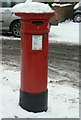
Postbox W4 11 Antrobus Road/Bollo Lane
An example of the rare 'anonymous' pillar box of the 1880s, cast without the royal cipher.
Image: © Alan Murray-Rust
Taken: 19 Dec 2010
0.05 miles
7
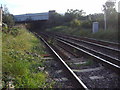
Southbound North London line, from Bollo Lane
Image: © David Howard
Taken: 28 Sep 2008
0.06 miles