IMAGES TAKEN NEAR TO
Bollo Lane, LONDON, W4 5LE
Introduction
This page details the photographs taken nearby to Bollo Lane, W4 5LE by members of the Geograph project.
The Geograph project started in 2005 with the aim of publishing, organising and preserving representative images for every square kilometre of Great Britain, Ireland and the Isle of Man.

There are currently over 7.5m images from over14,400 individuals and you can help contribute to the project by visiting https://www.geograph.org.uk
Image Map
Images are licensed for reuse under creativecommons.org/licenses/by-sa/2.0
Notes
- Clicking on the map will re-center to the selected point.
- The higher the marker number, the further away the image location is from the centre of the postcode.
Image Listing (270 Images Found)
Images are licensed for reuse under creativecommons.org/licenses/by-sa/2.0
Image
Details
Distance
2
New flats, Bollo Lane, Acton Lane Junction
Image: © Alex McGregor
Taken: 11 Jan 2012
0.02 miles
3
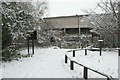
The entrance to Gunnersbury Triangle Nature Reserve
Looking from inside to the gate on Bollo Lane; the concrete wall behind is shelter for the elevated platform of Chiswick Park Station.
Image: © Alan Murray-Rust
Taken: 19 Dec 2010
0.02 miles
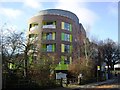
4
View of murals on a wall in the Gunnersbury Triangle Nature Reserve
Looking south-southeast.
Image: © Robert Lamb
Taken: 12 May 2018
0.02 miles
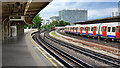
5
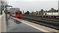
Westbound train departing Chiswick Park Station
Image: © David Martin
Taken: 11 Apr 2016
0.03 miles
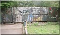
6
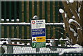
Acton Lane Junction
Notice detailing the change of ownership between London Underground Ltd and Network Rail - see http://www.geograph.org.uk/photo/2205607 .
Image: © Alan Murray-Rust
Taken: 19 Dec 2010
0.03 miles
7
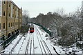
Acton Lane Junction - but not a point in sight
Many years ago, a line did indeed diverge to the right at this point, making the east side of Gunnersbury Triangle, but even so this is a junction. The gap in the conductor rails indicates the change of ownership between London Underground Limited and Network Rail, http://www.geograph.org.uk/photo/2205640 and there are plenty of other instances from the past history of British railway companies where an end-on meet like this was named as a junction.
Image: © Alan Murray-Rust
Taken: 19 Dec 2010
0.03 miles
8
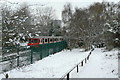
Richmond line train
Seen passing Gunnersbury Triangle Nature Reserve at Acton Lane Junction
Image: © Alan Murray-Rust
Taken: 19 Dec 2010
0.03 miles
9
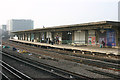
Chiswick Park LUL station
This is the eastbound District Line platform looking west. Only District Line trains call at this station; the more frequent Piccadilly Line trains pass through it on the tracks in the middle. Rebuilt in 1932, Chiswick Park is a bleak-looking station whose impressive tower nevertheless makes it stand out.
Image: © David Kemp
Taken: 12 Mar 2016
0.03 miles
10
Chiswick Park
Chiswick Park London Underground Station.
Image: © Peter McDermott
Taken: 24 Jun 2022
0.03 miles