IMAGES TAKEN NEAR TO
John Bull Place, LONDON, W4 5GW
Introduction
This page details the photographs taken nearby to John Bull Place, W4 5GW by members of the Geograph project.
The Geograph project started in 2005 with the aim of publishing, organising and preserving representative images for every square kilometre of Great Britain, Ireland and the Isle of Man.

There are currently over 7.5m images from over14,400 individuals and you can help contribute to the project by visiting https://www.geograph.org.uk
Image Map
Images are licensed for reuse under creativecommons.org/licenses/by-sa/2.0
Notes
- Clicking on the map will re-center to the selected point.
- The higher the marker number, the further away the image location is from the centre of the postcode.
Image Listing (135 Images Found)
Images are licensed for reuse under creativecommons.org/licenses/by-sa/2.0
Image
Details
Distance

2
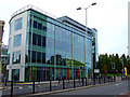
The Building
"The Building" on Chiswick High Road, opposite Gunnersbury railway station.
Image: © Thomas Nugent
Taken: 9 Oct 2011
0.03 miles
3

Chiswick High Road
At Gunnersbury station.
Image: © Thomas Nugent
Taken: 9 Oct 2011
0.03 miles
4

Chiswick High Road
At Gunnersbury railway station.
Image: © Thomas Nugent
Taken: 9 Oct 2011
0.03 miles
5

"The Gunnersbury" on Chiswick High Road
Image: © Neil Theasby
Taken: 23 Feb 2019
0.03 miles

7
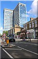
Chiswick Tower, Gunnersbury
Home of the British Standards Institute www.bsigroup.com
Image: © David Howard
Taken: 14 Jun 2020
0.05 miles
9
Chiswick High Road
Gunnersbury railway station is to the right.
Image: © Thomas Nugent
Taken: 9 Oct 2011
0.05 miles
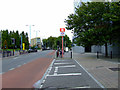
10

Chiswick High Road
An ambulance speeds along the road on a quiet Sunday afternoon.
Image: © Thomas Nugent
Taken: 9 Oct 2011
0.05 miles