IMAGES TAKEN NEAR TO
Kingswood Terrace, LONDON, W4 5BN
Introduction
This page details the photographs taken nearby to Kingswood Terrace, W4 5BN by members of the Geograph project.
The Geograph project started in 2005 with the aim of publishing, organising and preserving representative images for every square kilometre of Great Britain, Ireland and the Isle of Man.

There are currently over 7.5m images from over14,400 individuals and you can help contribute to the project by visiting https://www.geograph.org.uk
Image Map
Images are licensed for reuse under creativecommons.org/licenses/by-sa/2.0
Notes
- Clicking on the map will re-center to the selected point.
- The higher the marker number, the further away the image location is from the centre of the postcode.
Image Listing (186 Images Found)
Images are licensed for reuse under creativecommons.org/licenses/by-sa/2.0
Image
Details
Distance
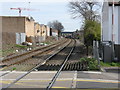
1
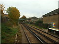
North London Line, W3
From the end of South Acton station.
Image: © Phillip Perry
Taken: 31 Oct 2010
0.01 miles
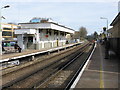
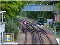
3
South Acton Station
Looking east from the station footbridge
Image: © Alan Murray-Rust
Taken: 22 Jul 2008
0.03 miles
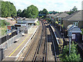
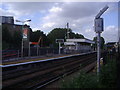
6
Tracks at South Acton station
Viewed from the station footbridge.
Image: © Thomas Nugent
Taken: 9 Oct 2011
0.04 miles
8

New flats at South Acton
Part of the regeneration of the post-WW2 South Acton Estate.
Image: © Alan Murray-Rust
Taken: 10 Jan 2012
0.04 miles
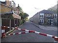
10
South Acton station from Bollo Lane
Taken from the level crossing on the freight-only line to Brentford.
Image: © Peter Whatley
Taken: 6 Apr 2010
0.05 miles