IMAGES TAKEN NEAR TO
Church Path, LONDON, W4 5BL
Introduction
This page details the photographs taken nearby to Church Path, W4 5BL by members of the Geograph project.
The Geograph project started in 2005 with the aim of publishing, organising and preserving representative images for every square kilometre of Great Britain, Ireland and the Isle of Man.

There are currently over 7.5m images from over14,400 individuals and you can help contribute to the project by visiting https://www.geograph.org.uk
Image Map
Images are licensed for reuse under creativecommons.org/licenses/by-sa/2.0
Notes
- Clicking on the map will re-center to the selected point.
- The higher the marker number, the further away the image location is from the centre of the postcode.
Image Listing (210 Images Found)
Images are licensed for reuse under creativecommons.org/licenses/by-sa/2.0
Image
Details
Distance
1
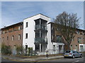
Church Gate House, Acton Green
Modern housing block on the junction of Church Path and Steele Road.
Built on the site of a former church.
Image: © David Anstiss
Taken: 14 Apr 2013
0.01 miles
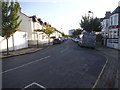
2

Rothschild Road
This part of town, although shown on the map as South Acton is specifically known to residents as Chiswick Park, and has this as part of the postal address. The building at the end of the street was formerly a laundry but now houses studios.
Image: © Alan Murray-Rust
Taken: 8 Mar 2008
0.04 miles
3
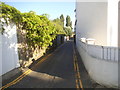
Houghton Lane, Acton
It's so narrow it doesn't appear on maps as a road, but it is one.
Image: © David Howard
Taken: 16 May 2015
0.06 miles
4

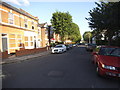
The Island
This strangely proportioned building sits on a small island entirely surrounded by roadways; why this should be so in a relatively formally developed area is unclear.
Image: © Alan Murray-Rust
Taken: 8 Mar 2008
0.07 miles
5
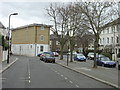
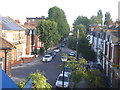
Church Path and Cleveland Road
The two roadways with the trees between them are in fact separate roads, both bi-directional - Church Path to the left and Cleveland Road to the right. The strange building at the end is called The Island, for obvious reasons.
Image: © Alan Murray-Rust
Taken: 8 Mar 2008
0.07 miles
6
Church Path, Acton
From the railway bridge
Image: © David Howard
Taken: 16 May 2015
0.08 miles
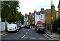
9
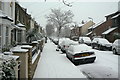
Rothschild Road
Looking south west during the heavy snowfall on 18 December 2010
Image: © Alan Murray-Rust
Taken: 18 Dec 2010
0.09 miles