IMAGES TAKEN NEAR TO
Beaumont Road, LONDON, W4 5AP
Introduction
This page details the photographs taken nearby to Beaumont Road, W4 5AP by members of the Geograph project.
The Geograph project started in 2005 with the aim of publishing, organising and preserving representative images for every square kilometre of Great Britain, Ireland and the Isle of Man.

There are currently over 7.5m images from over14,400 individuals and you can help contribute to the project by visiting https://www.geograph.org.uk
Image Map
Images are licensed for reuse under creativecommons.org/licenses/by-sa/2.0
Notes
- Clicking on the map will re-center to the selected point.
- The higher the marker number, the further away the image location is from the centre of the postcode.
Image Listing (146 Images Found)
Images are licensed for reuse under creativecommons.org/licenses/by-sa/2.0
Image
Details
Distance
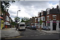
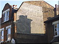
1
Acton Lane
Houses along the west side of the B490. The newer cream building on the right is a block of ten flats.
Image: © Derek Harper
Taken: 21 Mar 2013
0.04 miles
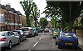
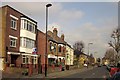
5
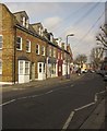
Acton Lane
Shops in a terrace along the B490 between Acton Green and Acton.
Image: © Derek Harper
Taken: 21 Mar 2013
0.06 miles

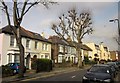
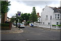
7
Church Path, Acton
From the railway bridge
Image: © David Howard
Taken: 16 May 2015
0.07 miles
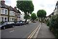
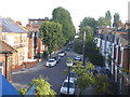
8
Acton Lane
Passing a printers, and the junction with Reynolds Lane with an off-licence on the corner.
Image: © Derek Harper
Taken: 21 Mar 2013
0.07 miles