IMAGES TAKEN NEAR TO
Chiswick High Road, LONDON, W4 4HH
Introduction
This page details the photographs taken nearby to Chiswick High Road, W4 4HH by members of the Geograph project.
The Geograph project started in 2005 with the aim of publishing, organising and preserving representative images for every square kilometre of Great Britain, Ireland and the Isle of Man.

There are currently over 7.5m images from over14,400 individuals and you can help contribute to the project by visiting https://www.geograph.org.uk
Image Map
Images are licensed for reuse under creativecommons.org/licenses/by-sa/2.0
Notes
- Clicking on the map will re-center to the selected point.
- The higher the marker number, the further away the image location is from the centre of the postcode.
Image Listing (264 Images Found)
Images are licensed for reuse under creativecommons.org/licenses/by-sa/2.0
Image
Details
Distance
1
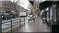
Chiswick High Road in the rain
Shelter provided by cafe awnings.
Image: © David Martin
Taken: 11 Apr 2016
0.01 miles
2
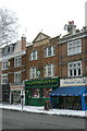
Connolly's, Chiswick High Road
A glance up at the pediment http://www.geograph.org.uk/photo/2205576 shows that this pub was originally named The Robin Hood.
Image: © Alan Murray-Rust
Taken: 19 Dec 2010
0.01 miles
3
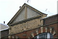
The Robin Hood
A relic of an earlier name for what is now called Connolly's http://www.geograph.org.uk/photo/2205568 .
Image: © Alan Murray-Rust
Taken: 19 Dec 2010
0.01 miles
4
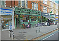
Irish Pub - Chiswick High Road
Turnham Green
Image: © Anthony O'Neil
Taken: 9 Jul 2019
0.02 miles
5
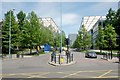
Chiswick: Park
This park and these residential buildings are situated in the centre of the grid square, slightly to the west. The buildings are on the west side of the park. This square consists of commercial businesses, residential area, two greens, a few pubs and has at least three churches.
Image: © Pam Brophy
Taken: 10 May 2005
0.03 miles
8
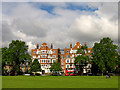
Arlington Park Mansions
An ornate group of early 20th century flats on the west side of Turnham Green.
Image: © Alan Murray-Rust
Taken: 19 Dec 2010
0.04 miles
9
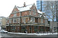
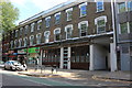
The Old Pack Horse
On the corner of Chiswick High Road and Acton Lane. It is listed Grade II as representing a largely unaltered example of a pub by Fullers' own house architect, Nowell Parr. It is a fine example of the use of terracotta to imitate Portland stone for the window surrounds. The same material is also used, in glazed brown form, for the facing of the ground floor http://www.geograph.org.uk/photo/2205584. Fullers are still functioning as a private traditional brewery.
Image: © Alan Murray-Rust
Taken: 19 Dec 2010
0.04 miles
10
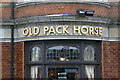
The Old Pack Horse, detail
As well as the fine terracotta detailing, the bars still retain their original stained glass designs, featuring either the pack horse for the pub's name (as seen here) or the brewers' Griffin crest http://www.geograph.org.uk/photo/2205583.
Image: © Alan Murray-Rust
Taken: 19 Dec 2010
0.04 miles