IMAGES TAKEN NEAR TO
Station Approach, Chiswick High Road, LONDON, W4 4AN
Introduction
This page details the photographs taken nearby to Station Approach, Chiswick High Road, W4 4AN by members of the Geograph project.
The Geograph project started in 2005 with the aim of publishing, organising and preserving representative images for every square kilometre of Great Britain, Ireland and the Isle of Man.

There are currently over 7.5m images from over14,400 individuals and you can help contribute to the project by visiting https://www.geograph.org.uk
Image Map
Images are licensed for reuse under creativecommons.org/licenses/by-sa/2.0
Notes
- Clicking on the map will re-center to the selected point.
- The higher the marker number, the further away the image location is from the centre of the postcode.
Image Listing (132 Images Found)
Images are licensed for reuse under creativecommons.org/licenses/by-sa/2.0
Image
Details
Distance
1
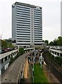
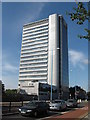
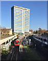
British Standards Institution, 389 Chiswick High Road, Chiswick, London
This modern building is the HQ of the BSI, which was founded in 1901, being the world's first national standards body. It has expanded considerably since that time and currently has 65 offices worldwide serving clients in 150 countries. In the foreground is Gunnersbury Station. Photographed from the railway bridge in Wellesley Road.
Image: © L S Wilson
Taken: 4 May 2012
0.01 miles
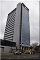
2
Chiswick Tower
Chiswick Tower at Gunnersbury.
Image: © Peter McDermott
Taken: 23 Jun 2022
0.01 miles
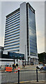
5
BSI (British Standards Institution) Building at Gunnersbury, West London
Image: © Richard Rogerson
Taken: 11 Sep 2009
0.01 miles
6
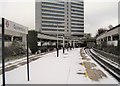
Gunnersbury railway and Underground station, Greater London
Opened in 1869 as Brentford Road by the London & South Western Railway on the line from Richmond to Hammersmith, it was renamed in 1871 to Gunnersbury.
View north west towards Hammersmith, also the North London line to Willesden. Like 55% of the London Underground network, this part is actually overground.
Image: © Nigel Thompson
Taken: 17 Dec 2010
0.01 miles
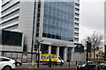
9
Gunnersbury Station, Chiswick
Seen from the Wellesley Road bridge, the station is on the Overground Stratford to Richmond line, and the Underground District Line. The tower block is the BSI headquarters on Chiswick High Road.
Image: © Paul Harrop
Taken: 18 Nov 2018
0.02 miles
10
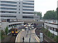
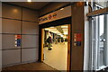
Gunnersbury station
Looking at Gunnersbury station from Wellesley Road, the 3 coach train on the left is part of the newly created 'London Overground' network, but still in the old 'Silverlink' livery as part of the North London Line. The car park surrounding the platforms and the building above all belong to BSI. The station is shared with the 'District Line' (Richmond Branch) of the London Underground.
Image: © Phillip Perry
Taken: 29 May 2008
0.03 miles