IMAGES TAKEN NEAR TO
Chiswick Staithe, Hartington Road, LONDON, W4 3TP
Introduction
This page details the photographs taken nearby to Chiswick Staithe, Hartington Road, W4 3TP by members of the Geograph project.
The Geograph project started in 2005 with the aim of publishing, organising and preserving representative images for every square kilometre of Great Britain, Ireland and the Isle of Man.

There are currently over 7.5m images from over14,400 individuals and you can help contribute to the project by visiting https://www.geograph.org.uk
Image Map
Images are licensed for reuse under creativecommons.org/licenses/by-sa/2.0
Notes
- Clicking on the map will re-center to the selected point.
- The higher the marker number, the further away the image location is from the centre of the postcode.
Image Listing (110 Images Found)
Images are licensed for reuse under creativecommons.org/licenses/by-sa/2.0
Image
Details
Distance
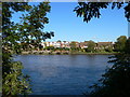
2
Housing in Chiswick Staithe Grove Park
Viewed from across the Thames at Kew.
Image: © Rod Allday
Taken: 25 Jun 2011
0.04 miles
3
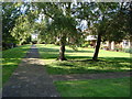
Thames Village, Chiswick
The walkway in front of the riverside gardens with the Thames on the left
Image: © Iain Crump
Taken: 3 Sep 2007
0.04 miles
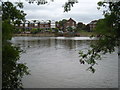
4
Houses with quays on the river Thames
Seen from the Thames Path, on the right bank of the river.
Image: © Eirian Evans
Taken: 20 Oct 2010
0.06 miles
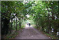
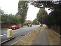
5
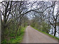
Grove Park: Hartington Road, W4 & Thames Path
At first sight this looks like an unlikely setting for a long distance footpath, but the Thames Path has to part company with the river here for about a kilometre and run parallel to it, and about 200 metres away, through the Grove Park conservation area. The tree with the yellowish foliage is a false acacia.
Image: © Nigel Cox
Taken: 3 Oct 2007
0.07 miles

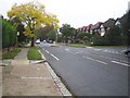
7
Hartington Road, Grove Park
Despite being a straight major road they have turned it into an obstacle course with alternate islands blocking each side.
Image: © David Howard
Taken: 18 Jul 2015
0.10 miles
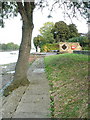
8
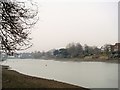
Thames view
A view of the River Thames seen from the Thames Path.
Image: © Michael Dibb
Taken: 26 Jan 2017
0.10 miles
9
The Thames Path in early spring
March 21st, and hawthorn leaves have just started to open along this stretch of the path, above Chiswick Bridge. A few minutes further on, as I cycled upstream, my nose reminded me that I was passing a sewage works.
Locally, we still refer to the Thames Path as 'the tow path', even though it must be more than a century since it was used for the towing of barges. The river bank must have been more open then, as tow-ropes would be fouled by any tree growing between path and river.
Image: © Stefan Czapski
Taken: 21 Mar 2011
0.11 miles