IMAGES TAKEN NEAR TO
Thames Road, LONDON, W4 3RE
Introduction
This page details the photographs taken nearby to Thames Road, W4 3RE by members of the Geograph project.
The Geograph project started in 2005 with the aim of publishing, organising and preserving representative images for every square kilometre of Great Britain, Ireland and the Isle of Man.

There are currently over 7.5m images from over14,400 individuals and you can help contribute to the project by visiting https://www.geograph.org.uk
Image Map
Images are licensed for reuse under creativecommons.org/licenses/by-sa/2.0
Notes
- Clicking on the map will re-center to the selected point.
- The higher the marker number, the further away the image location is from the centre of the postcode.
Image Listing (251 Images Found)
Images are licensed for reuse under creativecommons.org/licenses/by-sa/2.0
Image
Details
Distance
1
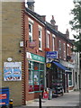
Chiswick: Strand-on-the-Green Post Office
The post office is at 54 Thames Road, the first of a row of shops, but the road just behind us is Strand-on-the-Green, like the suburb name. There has been a post office hereabouts since 1 August 1876, apart from a closure between November 1900 and July 1908.
Image: © Chris Downer
Taken: 12 Sep 2014
0.02 miles
2
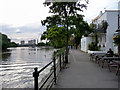
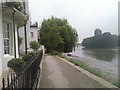
Towpath, North Bank of The Thames at Kew
As seen from the City Barge.
Image: © Christine Matthews
Taken: 11 May 2011
0.03 miles
3
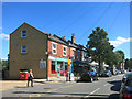
Strand on the Green Post Office
In Thames Road, one block in from the river.
Image: © Des Blenkinsopp
Taken: 8 Sep 2016
0.03 miles
5
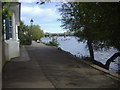
The riverfront at Strand-on-the-Green
Taken at low tide on a rather grey and misty day, the trees on the right are on the island of Oliver's Ait. The island gets its name from Oliver Cromwell.
Image: © Marathon
Taken: 8 Sep 2010
0.04 miles
6
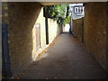
Ship Alley
The path that leads from Thames Road to the river at Strand on the Green.
Image: © David Howard
Taken: 21 Sep 2009
0.04 miles
7
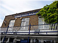
The City Barge, Kew
Looking up at the facade of the City Barge public house. Originally the Navigators Arms, when built in 1484, it was re-named the City Barge in the 19th century when the state barge of the Lord Mayor of the City of London had its winter moorings outside the Inn.
Image: © Christine Matthews
Taken: 11 May 2011
0.04 miles
8
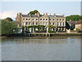
The Dutch House and its neighbours, Strand on the Green
Seen across the river from Kew.
The diamond pattern painted on the shutters of the Dutch House is very much in the Dutch tradition. I notice that since I was here last year, shutters and door have been repainted using a darker shade of blue http://www.geograph.org.uk/photo/2352960
On this occasion the tide was out. For an impression of the scene at high water see http://www.geograph.org.uk/photo/2318379
Image: © Stefan Czapski
Taken: 19 May 2012
0.04 miles
9
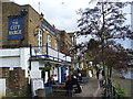
The City Barge
Historic Thames-side pub which gets its name from The Lord Mayor of London visiting here by barge.
Image: © Colin Smith
Taken: 29 Mar 2009
0.04 miles
10
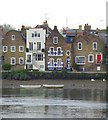
Strand on the Green, Kew
A terrace on the bank of the River Thames at Strand on the Green, Kew.
Image: © Malc McDonald
Taken: 2 Jul 2011
0.04 miles