IMAGES TAKEN NEAR TO
Strand On The Green, LONDON, W4 3PF
Introduction
This page details the photographs taken nearby to Strand On The Green, W4 3PF by members of the Geograph project.
The Geograph project started in 2005 with the aim of publishing, organising and preserving representative images for every square kilometre of Great Britain, Ireland and the Isle of Man.

There are currently over 7.5m images from over14,400 individuals and you can help contribute to the project by visiting https://www.geograph.org.uk
Image Map
Images are licensed for reuse under creativecommons.org/licenses/by-sa/2.0
Notes
- Clicking on the map will re-center to the selected point.
- The higher the marker number, the further away the image location is from the centre of the postcode.
Image Listing (388 Images Found)
Images are licensed for reuse under creativecommons.org/licenses/by-sa/2.0
Image
Details
Distance
1
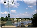
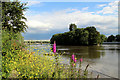
Strand on the Green, Chiswick from Kew Bridge
While only the first part of the riverside road is named “Strand on the Green”, the whole area, including the riverside “Thames Road”, is known as "Strand on the Green". The area was one of the original villages that are now together know as Chiswick.
Image: © Chris Reynolds
Taken: 1 Jun 2009
0.00 miles
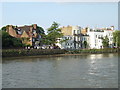
2
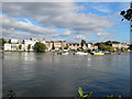
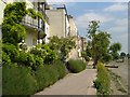
Attractive riverside houses at Strand on the Green
Seen from the Thames Path on the southern bank of the river.
Image: © Eirian Evans
Taken: 21 Oct 2010
0.01 miles
3
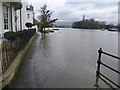
Flooded riverfront at Strand-on-the-Green
The riverfront at Strand-on-the-Green consists of a footpath running along the bank of the River Thames. It is overlooked by fine 18th-century houses and a collection of riverside pubs, and as it is on the tideway is regularly flooded by the river, especially when high tide combines with heavy flow from upriver as here in November 2012. The entrance of all the properties is raised above the path so that the view of the river is not spoiled. In some cases this has left rather strange effects such as front doors which are only four feet high - see http://www.geograph.org.uk/photo/2123728 In the distance is the railway bridge erected in 1869 which is now used by both the District Line and London Overground.
Image: © Marathon
Taken: 28 Nov 2012
0.01 miles
4
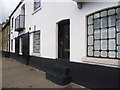
Steps to front door along the riverfront at Strand-on-the-Green
The riverfront at Strand-on-the-Green consists of a footpath running along the bank of the River Thames. It is overlooked by fine 18th-century houses and a collection of riverside pubs, and as it is on the tideway is regularly flooded by the river, especially when high tide combines with heavy flow from upriver as here in November 2012. The entrance of all the properties is raised above the path so that the view of the river is not spoiled. This is a typical example. In some cases, however, this has left rather strange effects such as front doors which are only four feet high - see http://www.geograph.org.uk/photo/3243229
Image: © Marathon
Taken: 28 Nov 2012
0.01 miles
5
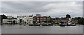
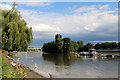
River Thames, Kew
As seen from the towpath to the east of the bridge.
Image: © Christine Matthews
Taken: 30 Jun 2011
0.01 miles
6
Strand on the Green
Elegant eighteenth century houses, with wooden balconies and stucco facades, overlooking the River Thames http://www.imagesofengland.org.uk/details/default.aspx?id=438658 http://www.imagesofengland.org.uk/Details/Default.aspx?id=438657&mode=adv http://www.imagesofengland.org.uk/Details/Default.aspx?id=438656&mode=adv .
Image: © Derek Harper
Taken: 9 Jun 2005
0.01 miles
8
Strand on the Green, on the River Thames at Chiswick
For more on Strand on the Green see http://en.wikipedia.org/wiki/Strand-on-the-Green and http://www.virtual-chiswick.ukonline.co.uk/strand_on_the_green/index.html
Image: © Chris Reynolds
Taken: 1 Jun 2009
0.02 miles
9
River Thames near Kew Bridge
Looking down river.
Image: © Christine Matthews
Taken: 30 Jun 2011
0.02 miles
10
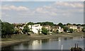
Strand on the Green, Kew
Buildings on the north bank of the River Thames at Kew.
Image: © Malc McDonald
Taken: 2 Jul 2011
0.02 miles