IMAGES TAKEN NEAR TO
Regent Street, LONDON, W4 3HN
Introduction
This page details the photographs taken nearby to Regent Street, W4 3HN by members of the Geograph project.
The Geograph project started in 2005 with the aim of publishing, organising and preserving representative images for every square kilometre of Great Britain, Ireland and the Isle of Man.

There are currently over 7.5m images from over14,400 individuals and you can help contribute to the project by visiting https://www.geograph.org.uk
Image Map
Images are licensed for reuse under creativecommons.org/licenses/by-sa/2.0
Notes
- Clicking on the map will re-center to the selected point.
- The higher the marker number, the further away the image location is from the centre of the postcode.
Image Listing (377 Images Found)
Images are licensed for reuse under creativecommons.org/licenses/by-sa/2.0
Image
Details
Distance
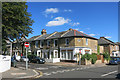
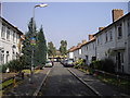
3
Wellesley Road
Seen from adjacent to the junction with Clarence Road, looking towards Chiswick High Street.
Image: © Martin Addison
Taken: 7 May 2010
0.08 miles
4
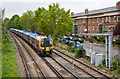
View from a Footbridge
A waterloo bound service from Hounslow approaches the bridge between Brooks Road and Brooks Lane on the section between Kew Bridge and Chiswick stations. On the right is Regent Street.
Image: © Martin Addison
Taken: 7 May 2010
0.08 miles
5

Chiswick - Pyrmont Road
Wikipedia : https://en.wikipedia.org/wiki/Chiswick
Image: © James Emmans
Taken: 13 Nov 2016
0.08 miles
6

Brentford Community Stadium from the air
Less than a mile from Griffin Park Image, the new home of Brentford FC is nearing completion. Part of a wider redevelopment scheme, the 17,250 seat stadium will also host rugby matches.
Further details: https://newstadium.brentfordfc.com/stadium and https://www.brentfordcommunitystadium.com/ .
The site is within a triangle formed by the M4 Great West Road and two railway lines.
Seen from a Heathrow bound flight from Prague.
Image: © Thomas Nugent
Taken: 7 Jan 2020
0.09 miles
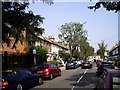
7
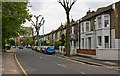
Clarence Road, Chiswick
An old corner shop is now a house.
Image: © Des Blenkinsopp
Taken: 8 Sep 2016
0.09 miles
10
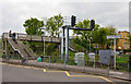
Footbridge to Brooks Lane
The footbridge crosses the Barnes to Hounslow railway line beside Chiswick Village, providing pedestrian access between Brooks Road and Brooks Lane.
Image: © Martin Addison
Taken: 7 May 2010
0.10 miles