IMAGES TAKEN NEAR TO
Stile Hall Gardens, LONDON, W4 3BP
Introduction
This page details the photographs taken nearby to Stile Hall Gardens, W4 3BP by members of the Geograph project.
The Geograph project started in 2005 with the aim of publishing, organising and preserving representative images for every square kilometre of Great Britain, Ireland and the Isle of Man.

There are currently over 7.5m images from over14,400 individuals and you can help contribute to the project by visiting https://www.geograph.org.uk
Image Map
Images are licensed for reuse under creativecommons.org/licenses/by-sa/2.0
Notes
- Clicking on the map will re-center to the selected point.
- The higher the marker number, the further away the image location is from the centre of the postcode.
Image Listing (397 Images Found)
Images are licensed for reuse under creativecommons.org/licenses/by-sa/2.0
Image
Details
Distance
1
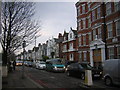
Rush hour traffic heads down Wellesley Road, W4
Traffic presumably coming off the A4 cuts along Wellesley Road to join the North Circular Road down to Kew Bridge.
Image: © Christopher Hilton
Taken: 27 Mar 2014
0.06 miles
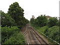
2
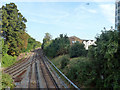
New Kew Junction
The Hounslow Loop Line is joined by the north - east side of the triangular junction with the line from Acton and Willesden. The up and down junctions are considerably staggered, possibly to accommodate waiting long eastbound freight trains on the triangle without fouling the north junction.
Image: © Robin Webster
Taken: 9 Sep 2012
0.07 miles
3
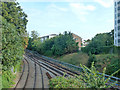
New Kew Junction
The Hounslow Loop Line on the right is joined by the north - east side of the triangular junction with the line from Acton and Willesden. The up and down junctions are considerably staggered, possibly to accommodate waiting long eastbound freight trains on the triangle without fouling the north junction.
Image: © Robin Webster
Taken: 9 Sep 2012
0.07 miles
5
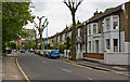
Wellesley Road
Seen from adjacent to the junction with Clarence Road, looking towards Chiswick High Street.
Image: © Martin Addison
Taken: 7 May 2010
0.07 miles
6
Wellesley Road and Chiswick High Street
Photograph of the traffic lights and the end of terrace at this junction.
Image: © Martin Addison
Taken: 7 May 2010
0.08 miles
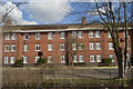
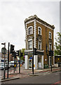
10

Stile Hall Parade
In many ways this is a typical row of London shops - in this case at the western end of Chiswick High Road near Kew Bridge. The convenience store bears the description 'food and wine' - very common in London but less so elsewhere.
Image: © Stephen McKay
Taken: 6 Mar 2018
0.08 miles