IMAGES TAKEN NEAR TO
Riverside Drive, LONDON, W4 2SP
Introduction
This page details the photographs taken nearby to Riverside Drive, W4 2SP by members of the Geograph project.
The Geograph project started in 2005 with the aim of publishing, organising and preserving representative images for every square kilometre of Great Britain, Ireland and the Isle of Man.

There are currently over 7.5m images from over14,400 individuals and you can help contribute to the project by visiting https://www.geograph.org.uk
Image Map
Images are licensed for reuse under creativecommons.org/licenses/by-sa/2.0
Notes
- Clicking on the map will re-center to the selected point.
- The higher the marker number, the further away the image location is from the centre of the postcode.
Image Listing (25 Images Found)
Images are licensed for reuse under creativecommons.org/licenses/by-sa/2.0
Image
Details
Distance
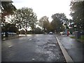
3
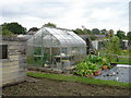
Chiswick allotments
Allotments off Riverside Drive
Image: © Iain Crump
Taken: 26 Sep 2004
0.07 miles
5
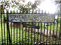
Sign to Staveley Gardens
Rather than an ordinary road name, this is a direction to one. They are very rare and probably made before the 60s by the design.
Image: © David Howard
Taken: 23 Aug 2014
0.08 miles
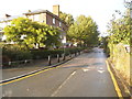
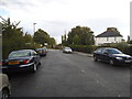
6
Riverside Drive at the junction of Great Chertsey Road
Image: © David Howard
Taken: 23 Aug 2014
0.09 miles
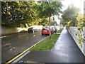
7
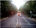
Great Chertsey Road, W4
At the junction of Staveley Road, from the front on the top deck of an E3 bus.
Image: © Phillip Perry
Taken: 3 Oct 2010
0.09 miles
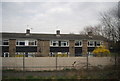
8
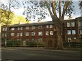
Flats by Great Chertsey Road, Chiswick
Image: © David Howard
Taken: 26 Oct 2018
0.12 miles
9
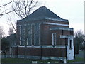
Chiswick Cemetery Chapel
As seen from Great Chertsey Road.
Image: © David Anstiss
Taken: 13 Jan 2013
0.14 miles