IMAGES TAKEN NEAR TO
Edensor Gardens, LONDON, W4 2RB
Introduction
This page details the photographs taken nearby to Edensor Gardens, W4 2RB by members of the Geograph project.
The Geograph project started in 2005 with the aim of publishing, organising and preserving representative images for every square kilometre of Great Britain, Ireland and the Isle of Man.

There are currently over 7.5m images from over14,400 individuals and you can help contribute to the project by visiting https://www.geograph.org.uk
Image Map
Images are licensed for reuse under creativecommons.org/licenses/by-sa/2.0
Notes
- Clicking on the map will re-center to the selected point.
- The higher the marker number, the further away the image location is from the centre of the postcode.
Image Listing (82 Images Found)
Images are licensed for reuse under creativecommons.org/licenses/by-sa/2.0
Image
Details
Distance
1

Edensor Gardens, Chiswick, W4
These flats were here well before the Corney Reach riverfront development only yards away from this picture on the River Thames.
Image: © Phillip Perry
Taken: 13 May 2008
0.01 miles
2
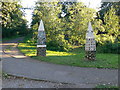
Pillars at the eastern entrance to Duke's Meadows
Two contemporary pillars, the left one depicts the Duke's Meadow area within a bend of the Thames.
Image: © Eirian Evans
Taken: 20 Oct 2010
0.06 miles
3

Orange Way after Wiltshire (615)
The view across the river is just upstream of Chiswick Pier.
Image: © Shazz
Taken: 23 Sep 2013
0.06 miles

6

Roundabout on Corney Road, Chiswick
Going clockwise around the roundabout.
Corney Road leads left towards Burlington Road. Pumping Station Road leads left towards Church Wharf. Corney Reach Way leads into the Corney Reach estate.
Thames Crescent leads right towards the River Thames.
Image: © David Anstiss
Taken: 14 Apr 2013
0.09 miles
7

Boats at Chiswick Pier
The Thames Path follows both sides of the River Thames here. This is on the north (Middlesex) side as the path heads towards Hammersmith Bridge. Beyond the trees on the opposite side is Leg O' Mutton Pond (also known as Lonsdale Road Reservoir) - see https://www.geograph.org.uk/photo/2303400
Image: © Marathon
Taken: 4 Apr 2018
0.09 miles

9
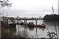
Chiswick: Boats moored on the River Thames
Opposite the Corney Reach private estate
Image: © Dr Neil Clifton
Taken: 3 Jan 2013
0.09 miles
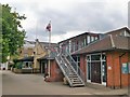
10
New Chiswick Pool
Modern built swimming pool on Edensor Road.
Image: © David Anstiss
Taken: 14 Apr 2013
0.10 miles