IMAGES TAKEN NEAR TO
Beverley Road, LONDON, W4 2LP
Introduction
This page details the photographs taken nearby to Beverley Road, W4 2LP by members of the Geograph project.
The Geograph project started in 2005 with the aim of publishing, organising and preserving representative images for every square kilometre of Great Britain, Ireland and the Isle of Man.

There are currently over 7.5m images from over14,400 individuals and you can help contribute to the project by visiting https://www.geograph.org.uk
Image Map
Images are licensed for reuse under creativecommons.org/licenses/by-sa/2.0
Notes
- Clicking on the map will re-center to the selected point.
- The higher the marker number, the further away the image location is from the centre of the postcode.
Image Listing (131 Images Found)
Images are licensed for reuse under creativecommons.org/licenses/by-sa/2.0
Image
Details
Distance
1
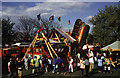
Carter's Steam Fair, Homefield Recreation ground, Chiswick
Victorian steam powered white knuckle ride courtesy of Carter's Steam Fair.
I'm stood on a lorry trailer for a bit of elevation.
Image: © Chris Allen
Taken: 13 Apr 1997
0.07 miles
2
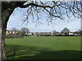
Homefield Recreation Ground, Chiswick
As seen from Chiswick Lane.
In one corner is a children's play area.
Image: © David Anstiss
Taken: 14 Apr 2013
0.08 miles
3
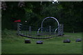
View of boulders and a bridge in the play area in Homefield Recreation Ground from Chiswick Lane
Looking north-northeast.
Image: © Robert Lamb
Taken: 12 May 2018
0.08 miles
4

View of boulders and climbing frames in the play area in the Homefield Recreation Ground
Looking north-northeast.
Image: © Robert Lamb
Taken: 12 May 2018
0.10 miles
5
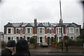
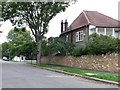
View of a terrace of distinctive Victorian houses on Chiswick Lane
Looking south-southwest.
Image: © Robert Lamb
Taken: 12 May 2018
0.12 miles
6
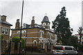
View of a church-like house on Chiswick Lane
Looking north-northwest.
Image: © Robert Lamb
Taken: 12 May 2018
0.14 miles
7
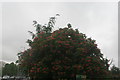
View of blossom in the Homefield South Recreation Ground from the subway under the A4
Looking north-northeast.
Image: © Robert Lamb
Taken: 12 May 2018
0.15 miles
8
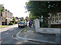
Corner of Airedale Road South and Netheravon Road South
Image: © Chris Gunns
Taken: 12 Sep 2009
0.15 miles
9
Netheravon Rd
Netheravon Rd is just south of the Great West Road at Chiswik very close to the river at Chiswick Eyot. Netheravon, like many of the north south roads in this area it has been cut in two by the main road.
Image: © Nigel Mykura
Taken: 19 Sep 2010
0.15 miles
10
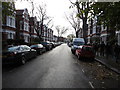
Netheravon Road
Route of the Tideway Tunnel
Image: © James Wood
Taken: 26 Nov 2015
0.15 miles