IMAGES TAKEN NEAR TO
Chiswick Lane, LONDON, W4 2JQ
Introduction
This page details the photographs taken nearby to Chiswick Lane, W4 2JQ by members of the Geograph project.
The Geograph project started in 2005 with the aim of publishing, organising and preserving representative images for every square kilometre of Great Britain, Ireland and the Isle of Man.

There are currently over 7.5m images from over14,400 individuals and you can help contribute to the project by visiting https://www.geograph.org.uk
Image Map
Images are licensed for reuse under creativecommons.org/licenses/by-sa/2.0
Notes
- Clicking on the map will re-center to the selected point.
- The higher the marker number, the further away the image location is from the centre of the postcode.
Image Listing (116 Images Found)
Images are licensed for reuse under creativecommons.org/licenses/by-sa/2.0
Image
Details
Distance
1
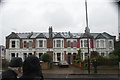
View of a terrace of distinctive Victorian houses on Chiswick Lane
Looking south-southwest.
Image: © Robert Lamb
Taken: 12 May 2018
0.03 miles
2
View of boulders and a bridge in the play area in Homefield Recreation Ground from Chiswick Lane
Looking north-northeast.
Image: © Robert Lamb
Taken: 12 May 2018
0.05 miles
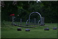
3

View of boulders and climbing frames in the play area in the Homefield Recreation Ground
Looking north-northeast.
Image: © Robert Lamb
Taken: 12 May 2018
0.07 miles
4
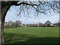
Homefield Recreation Ground, Chiswick
As seen from Chiswick Lane.
In one corner is a children's play area.
Image: © David Anstiss
Taken: 14 Apr 2013
0.08 miles
5
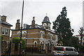
View of a church-like house on Chiswick Lane
Looking north-northwest.
Image: © Robert Lamb
Taken: 12 May 2018
0.08 miles
6
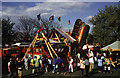
Carter's Steam Fair, Homefield Recreation ground, Chiswick
Victorian steam powered white knuckle ride courtesy of Carter's Steam Fair.
I'm stood on a lorry trailer for a bit of elevation.
Image: © Chris Allen
Taken: 13 Apr 1997
0.12 miles
7
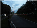
Sliproad from the A4 to Chiswick Lane
There is a complex one way system here to get traffic on and off the A4 in each direction
Image: © David Howard
Taken: 28 Sep 2013
0.13 miles
8

The Devonshire Arms, Devonshire Road, Chiswick
Image: © Alexander P Kapp
Taken: 17 Jul 2012
0.13 miles
9
Dorchester Grove, Chiswick
Linking the A4 with Chiswick High Road
Image: © David Howard
Taken: 28 Sep 2013
0.13 miles
10
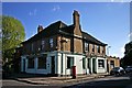
The Devonshire Arms (1), 126 Devonshire Road, Chiswick, London
Located on the corner of Devonshire Road and Ashbourne Grove. There was a pub here by 1888 known as the Manor Tavern. The present building, which replaced it, dates from 1924. For a few brief years from 2007 to June 2010 the well-known chef Gordon Ramsay had an interest in this former gastro pub. It later re-opened under new management but there was not enough custom to sustain it and it closed again in 2012. It was probably closed when this photograph was taken but later it was boarded up. As far as I can tell it has not re-opened and I have not been able to find out the building's current use.
Image
Image: © L S Wilson
Taken: 11 May 2012
0.14 miles