IMAGES TAKEN NEAR TO
Linden Gardens, LONDON, W4 2EQ
Introduction
This page details the photographs taken nearby to Linden Gardens, W4 2EQ by members of the Geograph project.
The Geograph project started in 2005 with the aim of publishing, organising and preserving representative images for every square kilometre of Great Britain, Ireland and the Isle of Man.

There are currently over 7.5m images from over14,400 individuals and you can help contribute to the project by visiting https://www.geograph.org.uk
Image Map
Images are licensed for reuse under creativecommons.org/licenses/by-sa/2.0
Notes
- Clicking on the map will re-center to the selected point.
- The higher the marker number, the further away the image location is from the centre of the postcode.
Image Listing (114 Images Found)
Images are licensed for reuse under creativecommons.org/licenses/by-sa/2.0
Image
Details
Distance
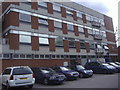
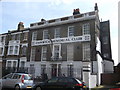
1
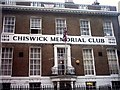
Chiswick Memorial Club, W4
It does what it says on the tin.
It's a kind of social/working mens club, in Bourne Place.
Image: © Phillip Perry
Taken: 3 Oct 2010
0.03 miles
4
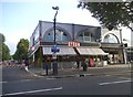
Byron hamburger restaurant on Chiswick High Road
Byron began in 2007 and offers top quality burgers at top prices https://www.byronhamburgers.com/story/
Image: © David Howard
Taken: 13 Jun 2015
0.05 miles
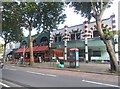
7
Cafe Rouge, Chiswick
Cafe on the junction of Linden Gardens and Chiswick High Road.
Image: © David Anstiss
Taken: 14 Apr 2013
0.05 miles
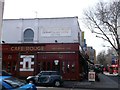
9
Afton House, Chiswick Memorial Club
Large Grade II listed house on Bourne Place.
Later converted into a Memorial Club.
Image: © David Anstiss
Taken: 14 Apr 2013
0.06 miles