IMAGES TAKEN NEAR TO
Duke Road, LONDON, W4 2BX
Introduction
This page details the photographs taken nearby to Duke Road, W4 2BX by members of the Geograph project.
The Geograph project started in 2005 with the aim of publishing, organising and preserving representative images for every square kilometre of Great Britain, Ireland and the Isle of Man.

There are currently over 7.5m images from over14,400 individuals and you can help contribute to the project by visiting https://www.geograph.org.uk
Image Map
Images are licensed for reuse under creativecommons.org/licenses/by-sa/2.0
Notes
- Clicking on the map will re-center to the selected point.
- The higher the marker number, the further away the image location is from the centre of the postcode.
Image Listing (125 Images Found)
Images are licensed for reuse under creativecommons.org/licenses/by-sa/2.0
Image
Details
Distance
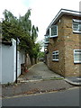
2
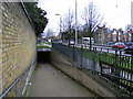
Entrance to subway under the Great West Road, Chiswick
The subway leads to Duke's Avenue on the other side of the A4
Image: © PAUL FARMER
Taken: 28 Mar 2010
0.10 miles
3
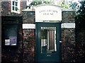
Hogarth's House, W4
A sad way to look after a 'national treasure'. After closing for refurbishment in 2008, and then a fire in 2009, has meant that the country house of William Hogarth was due to re-open in late 2010, but realistically that looks unlikely. The notice board to the left, the large padlock on the gate and the corrugated iron on the front door sees to that.
Image: © Phillip Perry
Taken: 3 Oct 2010
0.10 miles
4
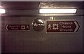
Decisions, decisions, W4
This one subway (under the A4 Great West Road) and entrances/exits are lucky enough to be in 4 different squares. As you can see both houses and grounds are next to each other.
Image: © Phillip Perry
Taken: 3 Oct 2010
0.11 miles
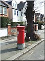
6
House in Sutherland Road Chiswick
The house is next to the Great West Road-A4
Image: © PAUL FARMER
Taken: 28 Mar 2010
0.12 miles
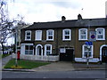
8
Chiswick: The former Duke of York public house
Despite being little more than a stone's throw from its home brewery this former Fuller's outlet has succumbed to inevitable closure.
For recent (2011, 2012 and 2012 again) views of the pub in happier times, please see
Image]
Image]
Image]
The road to the right is now a continuation of the old Fraser Street to the west, but was originally called Devonshire Place. All of the houses that fronted onto Devonshire Place have been demolished over time, so presumably the name was changed when there no more Devonshire Place addresses anymore.
Image: © Nigel Cox
Taken: 12 Sep 2018
0.13 miles
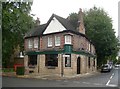
9
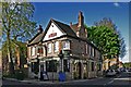
The Duke of York (1), 107 Devonshire Road, Chiswick, London
Located on the corner of Devonshire Road and Fraser Street. The original pub was purchased by Fullers in 1834 but predated that. It was rebuilt in 1927 and is still owned by Fullers.
Image
Image: © L S Wilson
Taken: 11 May 2012
0.13 miles
10
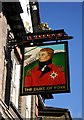
The Duke of York (2) - sign, 107 Devonshire Road, Chiswick, London
The title Duke of York is usually given to the second son of the monarch. The picture appears to be of Prince Frederick, Duke of York and Albany (1763-1827), who is associated with the Grand Old Duke of York nursery rhyme. In this he was supposed to have marched 10,000 men up a hill and down again. In the background of the sign some soldiers can be seen marching up a hill.
Image
Image: © L S Wilson
Taken: 11 May 2012
0.13 miles