IMAGES TAKEN NEAR TO
Chardin Road, LONDON, W4 1RJ
Introduction
This page details the photographs taken nearby to Chardin Road, W4 1RJ by members of the Geograph project.
The Geograph project started in 2005 with the aim of publishing, organising and preserving representative images for every square kilometre of Great Britain, Ireland and the Isle of Man.

There are currently over 7.5m images from over14,400 individuals and you can help contribute to the project by visiting https://www.geograph.org.uk
Image Map
Images are licensed for reuse under creativecommons.org/licenses/by-sa/2.0
Notes
- Clicking on the map will re-center to the selected point.
- The higher the marker number, the further away the image location is from the centre of the postcode.
Image Listing (235 Images Found)
Images are licensed for reuse under creativecommons.org/licenses/by-sa/2.0
Image
Details
Distance
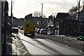
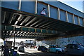
3
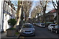
Thornton Avenue, Chiswick
I think the British invented the idea of blocking up short cuts. I haven't looked but suspect we probably have the highest proportion of them in the world.
Image: © David Howard
Taken: 7 Jun 2014
0.04 miles
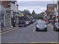
4
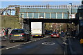
Turnham Green Terrace
At its junction with Chiswick High Road
Image: © Neil Theasby
Taken: 7 Oct 2018
0.05 miles
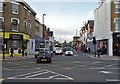
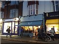
5
Turnham Green Terrace
The shops from Chiswick Green, Turnham Green itself is oddly the other side of the High Road.
Image: © David Howard
Taken: 28 Sep 2008
0.05 miles
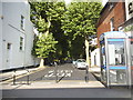
10
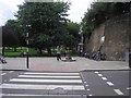
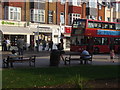
Turnham Green Park
The view from Turnham Green Terrace of the drinking fountain in Turnham Green Park (or Chiswick Common). The underground railway line (District and Piccadilly Lines) is on the right (at the top of the embankment).
Image: © Sandy Gemmill
Taken: 12 Jul 2007
0.06 miles