IMAGES TAKEN NEAR TO
Chiswick High Road, LONDON, W4 1PU
Introduction
This page details the photographs taken nearby to Chiswick High Road, W4 1PU by members of the Geograph project.
The Geograph project started in 2005 with the aim of publishing, organising and preserving representative images for every square kilometre of Great Britain, Ireland and the Isle of Man.

There are currently over 7.5m images from over14,400 individuals and you can help contribute to the project by visiting https://www.geograph.org.uk
Image Map
Images are licensed for reuse under creativecommons.org/licenses/by-sa/2.0
Notes
- Clicking on the map will re-center to the selected point.
- The higher the marker number, the further away the image location is from the centre of the postcode.
Image Listing (202 Images Found)
Images are licensed for reuse under creativecommons.org/licenses/by-sa/2.0
Image
Details
Distance
6
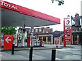
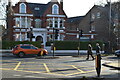
Total filling station, W4
One of those garages that doubles up as a supermarket. Corner of High Road and Brackley Road, W4
Image: © Phillip Perry
Taken: 29 May 2008
0.04 miles
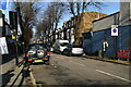
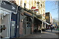
8
Chiswick Lane at the junction of Chiswick High Road
Image: © David Howard
Taken: 3 Sep 2013
0.06 miles
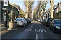
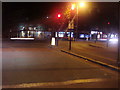
10
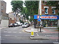
Mayfield Avenue
The view of Mayfield Avenue at the junction with Chiswick High Road.
Image: © Sandy Gemmill
Taken: 12 Jul 2007
0.06 miles