IMAGES TAKEN NEAR TO
Elliott Road, LONDON, W4 1PE
Introduction
This page details the photographs taken nearby to Elliott Road, W4 1PE by members of the Geograph project.
The Geograph project started in 2005 with the aim of publishing, organising and preserving representative images for every square kilometre of Great Britain, Ireland and the Isle of Man.

There are currently over 7.5m images from over14,400 individuals and you can help contribute to the project by visiting https://www.geograph.org.uk
Image Map
Images are licensed for reuse under creativecommons.org/licenses/by-sa/2.0
Notes
- Clicking on the map will re-center to the selected point.
- The higher the marker number, the further away the image location is from the centre of the postcode.
Image Listing (231 Images Found)
Images are licensed for reuse under creativecommons.org/licenses/by-sa/2.0
Image
Details
Distance
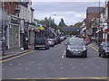
2
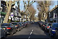
Turnham Green Terrace
At its junction with Chiswick High Road
Image: © Neil Theasby
Taken: 7 Oct 2018
0.04 miles
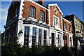
3
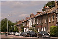
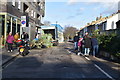
Cottages in Windmill Road, Chiswick
This delightful, quiet street is only a short distance from the hustle and bustle of the High Road.
Image: © john bristow
Taken: 8 Aug 2013
0.04 miles
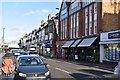
7
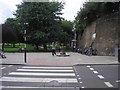
Turnham Green Park
The view from Turnham Green Terrace of the drinking fountain in Turnham Green Park (or Chiswick Common). The underground railway line (District and Piccadilly Lines) is on the right (at the top of the embankment).
Image: © Sandy Gemmill
Taken: 12 Jul 2007
0.06 miles
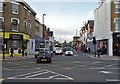
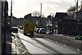
10
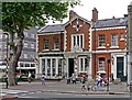
Former police station, Chiswick High Road, London W4
Image: © Jim Osley
Taken: 17 Jul 2015
0.06 miles