IMAGES TAKEN NEAR TO
Flanders Road, LONDON, W4 1NN
Introduction
This page details the photographs taken nearby to Flanders Road, W4 1NN by members of the Geograph project.
The Geograph project started in 2005 with the aim of publishing, organising and preserving representative images for every square kilometre of Great Britain, Ireland and the Isle of Man.

There are currently over 7.5m images from over14,400 individuals and you can help contribute to the project by visiting https://www.geograph.org.uk
Image Map
Images are licensed for reuse under creativecommons.org/licenses/by-sa/2.0
Notes
- Clicking on the map will re-center to the selected point.
- The higher the marker number, the further away the image location is from the centre of the postcode.
Image Listing (236 Images Found)
Images are licensed for reuse under creativecommons.org/licenses/by-sa/2.0
Image
Details
Distance
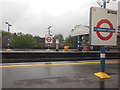
2

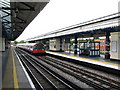
Turnham Green station
Turnham Green station was opened in 1869 by the London and South Western Railway on a new branch line to Richmond. From 1877 the Metropolitan District Railway ran trains through Turnham Green and from 1932 Piccadilly line trains ran through Turnham Green but without stopping. The tracks in the photograph are for Piccadilly line trains, which only stop here in the early morning or late evening. The District line tracks are out of the picture to the left and right.
Image: © Marathon
Taken: 4 May 2011
0.01 miles
5
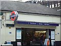
Turnham Green station, W4
Turnham Green station in Turnham Green Terrace, W4
Image: © Phillip Perry
Taken: 29 May 2008
0.03 miles
7
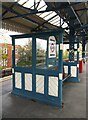
Passenger shelter at Turnham Green station
Image: © Stefan Czapski
Taken: 18 Apr 2022
0.03 miles
8
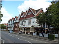
Turnham Green: The 'Tabard' public house and theatre
On Bath Road, just opposite the church. I was able to buy a glass of real perry in this pub - and there was also draught cider and a good selection of real ales. Upstairs is the highly-acclaimed theatre.
Image: © Dr Neil Clifton
Taken: 19 Sep 2012
0.03 miles
9
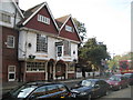
"The Tabard" public house, Bedford Park
Built in 1880 to designs by the architect Richard Norman Shaw, the public and adjacent buildings are all Grade II* listed and extensively described at this http://list.historicengland.org.uk/resultsingle.aspx?uid=1079594.
Image: © Jim Osley
Taken: 17 Jul 2015
0.03 miles
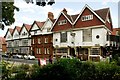
10
Bedford Park: The Tabard
Like Image on the opposite side of the B409 Bath Road, The Tabard Hotel was built to form a community focal point for the then new Bedford Park Estate, although possibly serving a different spiritual need. The Tabard was constructed in 1880 as a pioneering 'improved' pub, built in the Queen Anne style, and represented a rejection of the standard Victorian gin palace in favour of a more traditionally inspired and respectable inn. As such it was subsequently widely imitated elsewhere.
The two gabled bays forming The Tabard are part of a row of 7, the whole forming a Grade II* Listed building.
Image: © Nigel Cox
Taken: 25 Sep 2011
0.04 miles