IMAGES TAKEN NEAR TO
Welstead Way, LONDON, W4 1NL
Introduction
This page details the photographs taken nearby to Welstead Way, W4 1NL by members of the Geograph project.
The Geograph project started in 2005 with the aim of publishing, organising and preserving representative images for every square kilometre of Great Britain, Ireland and the Isle of Man.

There are currently over 7.5m images from over14,400 individuals and you can help contribute to the project by visiting https://www.geograph.org.uk
Image Map
Images are licensed for reuse under creativecommons.org/licenses/by-sa/2.0
Notes
- Clicking on the map will re-center to the selected point.
- The higher the marker number, the further away the image location is from the centre of the postcode.
Image Listing (143 Images Found)
Images are licensed for reuse under creativecommons.org/licenses/by-sa/2.0
Image
Details
Distance
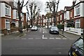
1
Prebend Gardens
An early example of mock timber framing, from the early years of the 20th century.
Image: © Alan Murray-Rust
Taken: 10 Jan 2012
0.05 miles
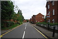
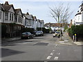
2
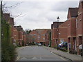
Welstead Way
Modern housing infill, following the line of the old North and South Western Railway branch from South Acton to Hammersmith and Chiswick. This lost its passenger service as early as 1919, although the branch remained open for coal traffic until 1965.
Image: © Alan Murray-Rust
Taken: 10 Jan 2012
0.05 miles
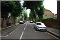
3
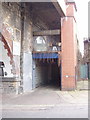
Motor repairs under the arches at Stamford Brook
This is the entrance in Prebend gardens to Frey Clement who have a workshop under the railway arches by Stamford Brook tube station.
Image: © David Hawgood
Taken: 25 Mar 2008
0.06 miles
4
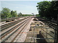
View from the end of the platform at Turnham Green
Turnham Green station was opened in 1869 by the London and South Western Railway on a new branch line to Richmond. From 1877 the Metropolitan District Railway ran trains through Turnham Green and from 1932 Piccadilly line trains ran through Turnham Green but without stopping. The centre tracks in the photograph are for Piccadilly line trains, which only stop at the station in the early morning or late evening. The District line tracks are to the left and right. In the far distance is a District line train stopped at Stamford Brook, the next station up the line.
Image: © Marathon
Taken: 4 May 2011
0.06 miles
7
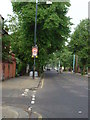
"Slow Down", W4
There are 2 of these either end of Bath Road.
Image: © Phillip Perry
Taken: 29 May 2008
0.07 miles