IMAGES TAKEN NEAR TO
Bath Road, LONDON, W4 1LY
Introduction
This page details the photographs taken nearby to Bath Road, W4 1LY by members of the Geograph project.
The Geograph project started in 2005 with the aim of publishing, organising and preserving representative images for every square kilometre of Great Britain, Ireland and the Isle of Man.

There are currently over 7.5m images from over14,400 individuals and you can help contribute to the project by visiting https://www.geograph.org.uk
Image Map
Images are licensed for reuse under creativecommons.org/licenses/by-sa/2.0
Notes
- Clicking on the map will re-center to the selected point.
- The higher the marker number, the further away the image location is from the centre of the postcode.
Image Listing (218 Images Found)
Images are licensed for reuse under creativecommons.org/licenses/by-sa/2.0
Image
Details
Distance
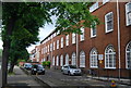
2
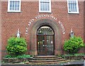
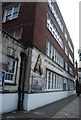
The Arts Educational Schools
Private school specialising in the performing arts. Based in the former Acton and Chiswick Polytechnic building on Bath Road.
Image: © Alan Murray-Rust
Taken: 10 Jan 2012
0.02 miles
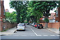
3
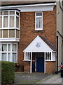
Porch of 28 Bath Road
Part of the original Bedford Park development and dated 1880, Listed Grade II.
Image: © Alan Murray-Rust
Taken: 10 Jan 2012
0.02 miles
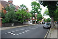
6
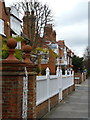
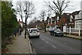
1 and 2 Rupert Gardens, Bedford Park
This is the Bath Road frontage of these two houses, either side of the road junction. Part of the original Bedford Park development, Listed Grade II.
Image: © Alan Murray-Rust
Taken: 10 Jan 2012
0.03 miles